Berg im Gau geodata
Berg im Gau (Bavaria) is a seat of a fourth-order administrative division; located in Germany in Europe/Berlin (GMT+2) time zone. With population of 1,195 people, there are 6577 cities with bigger population in this country. Compared to other cities in Germany, 87.4% of cities are located further ↑North; 70.6% of cities are located further ←West and 74.6% of cities have lower elevation than Berg im Gau. Note1
Administrative division(s):
- Level 1: Bavaria
- Level 2: Upper Bavaria
- Level 3: Landkreis Neuburg-Schrobenhausen
- Level 4: Berg im Gau


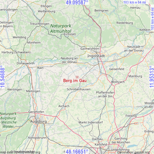
Berg im Gau GPS coordinates[2]
48° 37' 59.988" North, 11° 15' 0" East
| Map corner | latitude | longitude |
|---|---|---|
| Upper-left | 49.09587°, | 10.54688° |
| Center: | 48.63333°, | 11.25° |
| Lower-right: | 48.16651°, | 11.95313° |
| Map W x H: | 103.3×103.3 km | = 64.2×64.2mi |
| max Lat: | 55.01917° ⇑87.4% North |
| Berg im Gau: | 48.63333° |
| min Lat: | ⇓12.6% South 47.40724° |
| min Long | Berg im Gau | max Long |
| 5.92978° | 11.25° | 14.98853° |
| W 70.6%⇐ | ⇒29.4% E |
Elevation
Elevation of Berg im Gau is 394 m = 1293 ft, and this is 144.9 m = 475 ft above average elevation for this country.
| Max E: |
1256 m = 4121 ft | 25.4% |
| Berg im Gau | 394 m 1293 ft | |
| Avg. | 249.1 m = 817 ft | |
Min E: |
-5 m = -16 ft | 74.6% |
See also: Germany elevation on elevation.city.
Geographical zone
Berg im Gau is located in North temperate zone (between Tropic of Cancer and the Arctic Circle). Distance of this North polar circle is 1993.7 km =1238.8 mi to North.| Distance of | km | miles | from Berg im Gau |
|---|---|---|---|
| North Pole | 4599.5 | 2858 | to North |
| Arctic Circle | 1993.7 | 1238.8 | to North |
| Tropic Cancer | 2801.6 | 1740.8 | to South |
| Equator | 5407.5 | 3360.1 | to South |


Nearby cities:
15 places around Berg im Gau: (largest is in red/bold)
• Aresing
11.7 km =7.3 mi,  161°
161°
• Bergheim
14.2 km =8.8 mi,  2°
2°
• Brunnen
4.4 km =2.7 mi,  96°
96°
• Ehekirchen
11 km =6.8 mi,  270°
270°
• Gachenbach
14.9 km =9.3 mi,  184°
184°
• Karlshuld
6 km =3.7 mi,  25°
25°
• Karlskron
13.4 km =8.3 mi,  65°
65°
• Langenmosen
4 km =2.5 mi,  221°
221°
• Neuburg an der Donau
11.9 km =7.4 mi,  337°
337°
• Oberhausen
14.2 km =8.8 mi,  314°
314°
• Pöttmes
13.1 km =8.1 mi,  245°
245°
• Rohrenfels
9.1 km =5.7 mi, 310°
• Schrobenhausen
8.1 km =5 mi,  174°
174°
• Waidhofen
8.9 km =5.5 mi,  135°
135°
• Weichering
10.7 km =6.6 mi, 29°
Sources, notices
• [Note1] Compared only with cities in Germany existing in our database
• [Src1] Map data: © OpenStreetMap contributors (CC-BY-SA)
• [Src2] Other city data from geonames.org with taken over terms of usage.
• [Src3] Geographical zone / Annual Mean Temperature by Robert A. Rohde @ Wikipedia
