Karlshuld geodata
Karlshuld (Bavaria) is a seat of a fourth-order administrative division; located in Germany in Europe/Berlin (GMT+2) time zone. With population of 5,012 people, there are 2826 cities with bigger population in this country. Compared to other cities in Germany, 86.7% of cities are located further ↑North; 71.1% of cities are located further ←West and 72.4% of cities have lower elevation than Karlshuld. Note1
Administrative division(s):
- Level 1: Bavaria
- Level 2: Upper Bavaria
- Level 3: Landkreis Neuburg-Schrobenhausen
- Level 4: Karlshuld


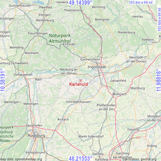
Karlshuld GPS coordinates[2]
48° 40' 54.84" North, 11° 17' 6.108" East
| Map corner | latitude | longitude |
|---|---|---|
| Upper-left | 49.14399°, | 10.58191° |
| Center: | 48.6819°, | 11.28503° |
| Lower-right: | 48.21553°, | 11.98816° |
| Map W x H: | 103.2×103.2 km | = 64.1×64.1mi |
| max Lat: | 55.01917° ⇑86.7% North |
| Karlshuld: | 48.6819° |
| min Lat: | ⇓13.3% South 47.40724° |
| min Long | Karlshuld | max Long |
| 5.92978° | 11.28503° | 14.98853° |
| W 71.1%⇐ | ⇒28.9% E |
Elevation
Elevation of Karlshuld is 377 m = 1237 ft, and this is 127.9 m = 420 ft above average elevation for this country.
| Max E: |
1256 m = 4121 ft | 27.6% |
| Karlshuld | 377 m 1237 ft | |
| Avg. | 249.1 m = 817 ft | |
Min E: |
-5 m = -16 ft | 72.4% |
See also: Germany elevation on elevation.city.
Geographical zone
Karlshuld is located in North temperate zone (between Tropic of Cancer and the Arctic Circle). Distance of this North polar circle is 1988.3 km =1235.5 mi to North.| Distance of | km | miles | from Karlshuld |
|---|---|---|---|
| North Pole | 4594.1 | 2854.6 | to North |
| Arctic Circle | 1988.3 | 1235.5 | to North |
| Tropic Cancer | 2807 | 1744.2 | to South |
| Equator | 5412.9 | 3363.4 | to South |


Nearby cities:
15 places around Karlshuld: (largest is in red/bold)
• Baar-Ebenhausen
13.6 km =8.5 mi,  95°
95°
• Berg im Gau
6 km =3.7 mi,  205°
205°
• Bergheim
9 km =5.6 mi,  346°
346°
• Brunnen
6.1 km =3.8 mi,  163°
163°
• Egweil
11.9 km =7.4 mi,  341°
341°
• Ingolstadt
13.7 km =8.5 mi,  47°
47°
• Karlskron
9.7 km =6 mi,  89°
89°
• Langenmosen
9.9 km =6.2 mi, 212°
• Neuburg an der Donau
9.1 km =5.7 mi,  307°
307°
• Oberhausen
13.5 km =8.4 mi,  289°
289°
• Reichertshofen
13.6 km =8.5 mi, 101°
• Rohrenfels
9.5 km =5.9 mi,  273°
273°
• Schrobenhausen
13.6 km =8.5 mi,  187°
187°
• Waidhofen
12.3 km =7.6 mi, 162°
• Weichering
4.7 km =2.9 mi,  34°
34°
Sources, notices
• [Note1] Compared only with cities in Germany existing in our database
• [Src1] Map data: © OpenStreetMap contributors (CC-BY-SA)
• [Src2] Other city data from geonames.org with taken over terms of usage.
• [Src3] Geographical zone / Annual Mean Temperature by Robert A. Rohde @ Wikipedia
