Althütte geodata
Althütte (Baden-Württemberg) is a seat of a fourth-order administrative division; located in Germany in Europe/Berlin (GMT+2) time zone. With population of 4,263 people, there are 3155 cities with bigger population in this country. Compared to other cities in Germany, 83.9% of cities are located further ↑North; 56.7% of cities are located further →East and 88.3% of cities have lower elevation than Althütte. Note1
Administrative division(s):
- Level 1: Baden-Württemberg
- Level 2: Regierungsbezirk Stuttgart
- Level 3: Rems-Murr-Kreis
- Level 4: Althütte


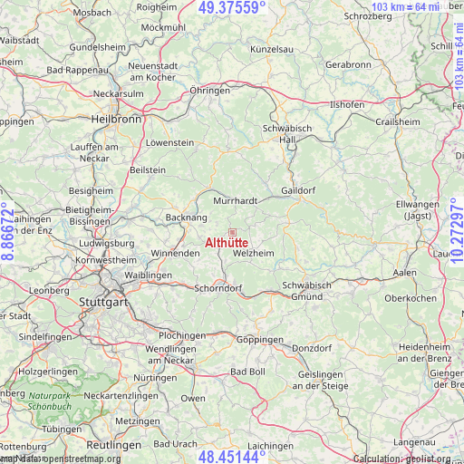
Althütte GPS coordinates[2]
48° 54' 56.34" North, 9° 34' 11.424" East
| Map corner | latitude | longitude |
|---|---|---|
| Upper-left | 49.37559°, | 8.86672° |
| Center: | 48.91565°, | 9.56984° |
| Lower-right: | 48.45144°, | 10.27297° |
| Map W x H: | 102.8×102.8 km | = 63.9×63.9mi |
| max Lat: | 55.01917° ⇑83.9% North |
| Althütte: | 48.91565° |
| min Lat: | ⇓16.1% South 47.40724° |
| min Long | Althütte | max Long |
| 5.92978° | 9.56984° | 14.98853° |
| W 43.3%⇐ | ⇒56.7% E |
Elevation
Elevation of Althütte is 497 m = 1631 ft, and this is 247.9 m = 813 ft above average elevation for this country.
| Max E: |
1256 m = 4121 ft | 11.7% |
| Althütte | 497 m 1631 ft | |
| Avg. | 249.1 m = 817 ft | |
Min E: |
-5 m = -16 ft | 88.3% |
See also: Germany elevation on elevation.city.
Geographical zone
Althütte is located in North temperate zone (between Tropic of Cancer and the Arctic Circle). Distance of this North polar circle is 1962.3 km =1219.3 mi to North.| Distance of | km | miles | from Althütte |
|---|---|---|---|
| North Pole | 4568.2 | 2838.5 | to North |
| Arctic Circle | 1962.3 | 1219.3 | to North |
| Tropic Cancer | 2833 | 1760.3 | to South |
| Equator | 5438.9 | 3379.6 | to South |


Nearby cities:
15 places around Althütte: (largest is in red/bold)
• Allmersbach im Tal
7.5 km =4.7 mi,  262°
262°
• Backnang
10.3 km =6.4 mi,  290°
290°
• Fichtenberg
13 km =8.1 mi,  52°
52°
• Gschwend
12.9 km =8 mi,  81°
81°
• Kaisersbach
5.3 km =3.3 mi,  72°
72°
• Mittelschöntal
13.2 km =8.2 mi,  284°
284°
• Murrhardt
7.4 km =4.6 mi,  0°
0°
• Oberrot
13.1 km =8.1 mi,  32°
32°
• Oppenweiler
11 km =6.8 mi,  312°
312°
• Plüderhausen
13.1 km =8.1 mi,  171°
171°
• Rudersberg
4.5 km =2.8 mi,  221°
221°
• Schorndorf
12.7 km =7.9 mi,  194°
194°
• Sulzbach an der Murr
11 km =6.8 mi,  332°
332°
• Urbach
11 km =6.8 mi,  177°
177°
• Welzheim
6.4 km =4 mi,  132°
132°
Sources, notices
• [Note1] Compared only with cities in Germany existing in our database
• [Src1] Map data: © OpenStreetMap contributors (CC-BY-SA)
• [Src2] Other city data from geonames.org with taken over terms of usage.
• [Src3] Geographical zone / Annual Mean Temperature by Robert A. Rohde @ Wikipedia
