Ernsgaden geodata
Ernsgaden (Bavaria) is a seat of a fourth-order administrative division; located in Germany in Europe/Berlin (GMT+2) time zone. With population of 1,445 people, there are 5987 cities with bigger population in this country. Compared to other cities in Germany, 86.1% of cities are located further ↑North; 75.5% of cities are located further ←West and 70.5% of cities have lower elevation than Ernsgaden. Note1
Administrative division(s):
- Level 1: Bavaria
- Level 2: Upper Bavaria
- Level 3: Landkreis Pfaffenhofen an der Ilm
- Level 4: Ernsgaden


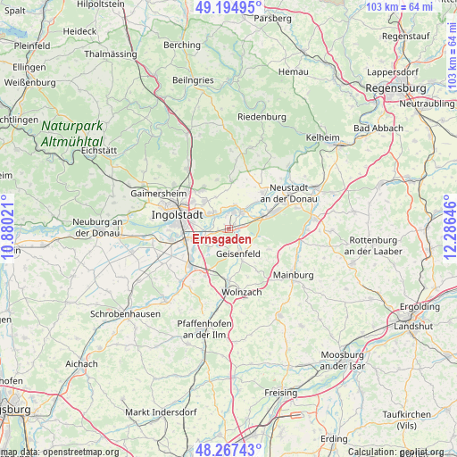
Ernsgaden GPS coordinates[2]
48° 43' 59.988" North, 11° 34' 59.988" East
| Map corner | latitude | longitude |
|---|---|---|
| Upper-left | 49.19495°, | 10.88021° |
| Center: | 48.73333°, | 11.58333° |
| Lower-right: | 48.26743°, | 12.28646° |
| Map W x H: | 103.1×103.1 km | = 64.1×64.1mi |
| max Lat: | 55.01917° ⇑86.1% North |
| Ernsgaden: | 48.73333° |
| min Lat: | ⇓13.9% South 47.40724° |
| min Long | Ernsgaden | max Long |
| 5.92978° | 11.58333° | 14.98853° |
| W 75.5%⇐ | ⇒24.5% E |
Elevation
Elevation of Ernsgaden is 362 m = 1188 ft, and this is 112.9 m = 370 ft above average elevation for this country.
| Max E: |
1256 m = 4121 ft | 29.5% |
| Ernsgaden | 362 m 1188 ft | |
| Avg. | 249.1 m = 817 ft | |
Min E: |
-5 m = -16 ft | 70.5% |
See also: Germany elevation on elevation.city.
Geographical zone
Ernsgaden is located in North temperate zone (between Tropic of Cancer and the Arctic Circle). Distance of this North polar circle is 1982.5 km =1231.9 mi to North.| Distance of | km | miles | from Ernsgaden |
|---|---|---|---|
| North Pole | 4588.4 | 2851.1 | to North |
| Arctic Circle | 1982.5 | 1231.9 | to North |
| Tropic Cancer | 2812.7 | 1747.7 | to South |
| Equator | 5418.6 | 3367 | to South |


Nearby cities:
15 places around Ernsgaden: (largest is in red/bold)
• Aiglsbach
10.3 km =6.4 mi,  116°
116°
• Baar-Ebenhausen
10.9 km =6.8 mi,  230°
230°
• Geisenfeld
5.9 km =3.7 mi,  158°
158°
• Großmehring
5.2 km =3.2 mi,  315°
315°
• Hepberg
13.3 km =8.3 mi, 318°
• Ingolstadt
12.2 km =7.6 mi,  286°
286°
• Karlskron
13.4 km =8.3 mi,  245°
245°
• Lenting
12.5 km =7.8 mi,  313°
313°
• Manching
6.8 km =4.2 mi, 254°
• Mindelstetten
13.9 km =8.6 mi,  20°
20°
• Münchsmünster
8.2 km =5.1 mi,  63°
63°
• Oberdolling
10.7 km =6.6 mi,  3°
3°
• Reichertshofen
12 km =7.5 mi, 225°
• Rohrbach
13 km =8.1 mi,  185°
185°
• Vohburg an der Donau
4.8 km =3 mi,  32°
32°
Sources, notices
• [Note1] Compared only with cities in Germany existing in our database
• [Src1] Map data: © OpenStreetMap contributors (CC-BY-SA)
• [Src2] Other city data from geonames.org with taken over terms of usage.
• [Src3] Geographical zone / Annual Mean Temperature by Robert A. Rohde @ Wikipedia
