Bornstedt geodata
Bornstedt (Saxony-Anhalt) is a seat of a fourth-order administrative division; located in Germany in Europe/Berlin (GMT+2) time zone. With population of 992 people, there are 7213 cities with bigger population in this country. Compared to other cities in Germany, 66.1% of cities are located further ↓South; 74% of cities are located further ←West and 54.1% of cities have higher elevation than Bornstedt. Note1


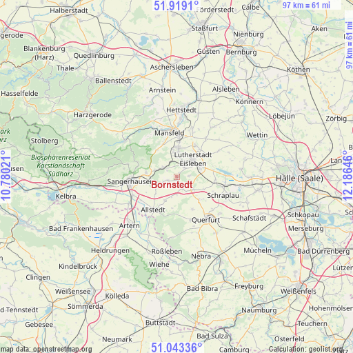
Bornstedt GPS coordinates[2]
51° 28' 59.988" North, 11° 28' 59.988" East
| Map corner | latitude | longitude |
|---|---|---|
| Upper-left | 51.9191°, | 10.78021° |
| Center: | 51.48333°, | 11.48333° |
| Lower-right: | 51.04336°, | 12.18646° |
| Map W x H: | 97.4×97.4 km | = 60.5×60.5mi |
| max Lat: | 55.01917° ⇑33.9% North |
| Bornstedt: | 51.48333° |
| min Lat: | ⇓66.1% South 47.40724° |
| min Long | Bornstedt | max Long |
| 5.92978° | 11.48333° | 14.98853° |
| W 74%⇐ | ⇒26% E |
Elevation
Elevation of Bornstedt is 196 m = 643 ft, and this is 53.1 m = 174 ft below average elevation for this country.
| Max E: |
1256 m = 4121 ft | 54.1% |
| Avg. | 249.1 m = 817 ft | |
| Bornstedt | 196 m = 643 ft | |
Min E: |
-5 m = -16 ft | 45.9% |
See also: Germany elevation on elevation.city.
Geographical zone
Bornstedt is located in North temperate zone (between Tropic of Cancer and the Arctic Circle). Distance of this North polar circle is 1676.8 km =1041.9 mi to North.| Distance of | km | miles | from Bornstedt |
|---|---|---|---|
| North Pole | 4282.7 | 2661.1 | to North |
| Arctic Circle | 1676.8 | 1041.9 | to North |
| Tropic Cancer | 3118.5 | 1937.7 | to South |
| Equator | 5724.4 | 3557 | to South |


Nearby cities:
15 places around Bornstedt: (largest is in red/bold)
• Ahlsdorf
7 km =4.3 mi,  350°
350°
• Beyernaumburg
6.2 km =3.9 mi,  260°
260°
• Bischofrode
3.4 km =2.1 mi,  83°
83°
• Blankenheim
4.6 km =2.9 mi,  305°
305°
• Eisleben Lutherstadt
6.7 km =4.2 mi,  42°
42°
• Emseloh
6.7 km =4.2 mi,  287°
287°
• Helbra
7.5 km =4.7 mi,  8°
8°
• Hergisdorf
5.6 km =3.5 mi,  0°
0°
• Holdenstedt
2.7 km =1.7 mi,  251°
251°
• Mittelhausen
5.7 km =3.5 mi,  195°
195°
• Osterhausen
3.6 km =2.2 mi,  155°
155°
• Rothenschirmbach
5.4 km =3.4 mi,  124°
124°
• Wimmelburg
4.5 km =2.8 mi,  21°
21°
• Wolferode
3.3 km =2.1 mi, 38°
• Wolferstedt
7.3 km =4.5 mi,  207°
207°
Sources, notices
• [Note1] Compared only with cities in Germany existing in our database
• [Src1] Map data: © OpenStreetMap contributors (CC-BY-SA)
• [Src2] Other city data from geonames.org with taken over terms of usage.
• [Src3] Geographical zone / Annual Mean Temperature by Robert A. Rohde @ Wikipedia
