Steinheim geodata
Steinheim (North Rhine-Westphalia) is a populated place; located in Germany in Europe/Berlin (GMT+2) time zone. With population of 13,797 people, there are 1157 cities with bigger population in this country. Compared to other cities in Germany, 70.8% of cities are located further ↓South; 64.1% of cities are located further →East and 60.6% of cities have higher elevation than Steinheim. Note1
Administrative division(s):
- Level 1: North Rhine-Westphalia
- Level 2: Regierungsbezirk Detmold
- Level 3: Kreis Höxter
- Level 4: Steinheim


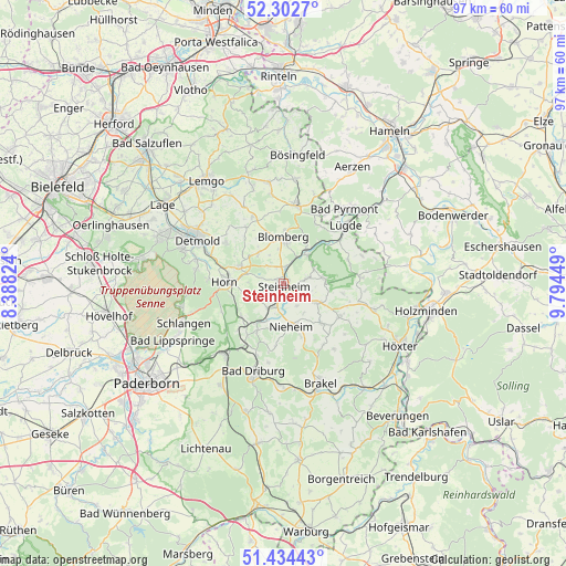
Steinheim GPS coordinates[2]
51° 52' 14.376" North, 9° 5' 28.896" East
| Map corner | latitude | longitude |
|---|---|---|
| Upper-left | 52.3027°, | 8.38824° |
| Center: | 51.87066°, | 9.09136° |
| Lower-right: | 51.43443°, | 9.79449° |
| Map W x H: | 96.5×96.5 km | = 60×60mi |
| max Lat: | 55.01917° ⇑29.2% North |
| Steinheim: | 51.87066° |
| min Lat: | ⇓70.8% South 47.40724° |
| min Long | Steinheim | max Long |
| 5.92978° | 9.09136° | 14.98853° |
| W 35.9%⇐ | ⇒64.1% E |
Elevation
Elevation of Steinheim is 148 m = 486 ft, and this is 101.1 m = 332 ft below average elevation for this country.
| Max E: |
1256 m = 4121 ft | 60.6% |
| Avg. | 249.1 m = 817 ft | |
| Steinheim | 148 m = 486 ft | |
Min E: |
-5 m = -16 ft | 39.4% |
See also: Germany elevation on elevation.city.
Geographical zone
Steinheim is located in North temperate zone (between Tropic of Cancer and the Arctic Circle). Distance of this North polar circle is 1633.7 km =1015.1 mi to North.| Distance of | km | miles | from Steinheim |
|---|---|---|---|
| North Pole | 4239.6 | 2634.4 | to North |
| Arctic Circle | 1633.7 | 1015.1 | to North |
| Tropic Cancer | 3161.6 | 1964.5 | to South |
| Equator | 5767.5 | 3583.8 | to South |


Nearby cities:
15 places around Steinheim: (largest is in red/bold)
• Altenbeken
15.6 km =9.7 mi,  221°
221°
• Bad Driburg
16.1 km =10 mi,  197°
197°
• Bad Meinberg
7.9 km =4.9 mi,  290°
290°
• Bad Pyrmont
16.9 km =10.5 mi,  40°
40°
• Barntrup
13.4 km =8.3 mi,  7°
7°
• Blomberg
8.1 km =5 mi,  359°
359°
• Brakel
18.2 km =11.3 mi,  159°
159°
• Detmold
16.8 km =10.4 mi,  296°
296°
• Horn
10 km =6.2 mi,  270°
270°
• Horn-Bad Meinberg
9 km =5.6 mi,  280°
280°
• Lügde
14.5 km =9 mi,  47°
47°
• Nieheim
7.5 km =4.7 mi,  168°
168°
• Schieder-Schwalenberg
7.2 km =4.5 mi,  84°
84°
• Schlangen
18.2 km =11.3 mi,  248°
248°
• Vahlbruch
18 km =11.2 mi,  71°
71°
Sources, notices
• [Note1] Compared only with cities in Germany existing in our database
• [Src1] Map data: © OpenStreetMap contributors (CC-BY-SA)
• [Src2] Other city data from geonames.org with taken over terms of usage.
• [Src3] Geographical zone / Annual Mean Temperature by Robert A. Rohde @ Wikipedia
