Bad Pyrmont geodata
Bad Pyrmont (Lower Saxony) is a populated place; located in Germany in Europe/Berlin (GMT+2) time zone. With population of 21,629 people, there are 696 cities with bigger population in this country. Compared to other cities in Germany, 72.1% of cities are located further ↓South; 61.5% of cities are located further →East and 66.2% of cities have higher elevation than Bad Pyrmont. Note1
Administrative division(s):
- Level 1: Lower Saxony
- Level 3: Landkreis Hameln-Pyrmont
- Level 4: Bad Pyrmont


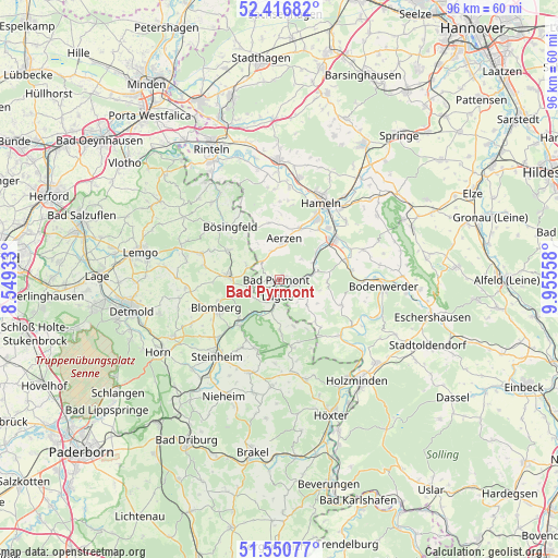
Bad Pyrmont GPS coordinates[2]
51° 59' 9.204" North, 9° 15' 8.856" East
| Map corner | latitude | longitude |
|---|---|---|
| Upper-left | 52.41682°, | 8.54933° |
| Center: | 51.98589°, | 9.25246° |
| Lower-right: | 51.55077°, | 9.95558° |
| Map W x H: | 96.3×96.3 km | = 59.8×59.8mi |
| max Lat: | 55.01917° ⇑27.9% North |
| Bad Pyrmont: | 51.98589° |
| min Lat: | ⇓72.1% South 47.40724° |
| min Long | Bad Pyrmont | max Long |
| 5.92978° | 9.25246° | 14.98853° |
| W 38.5%⇐ | ⇒61.5% E |
Elevation
Elevation of Bad Pyrmont is 113 m = 371 ft, and this is 136.1 m = 447 ft below average elevation for this country.
| Max E: |
1256 m = 4121 ft | 66.2% |
| Avg. | 249.1 m = 817 ft | |
| Bad Pyrmont | 113 m = 371 ft | |
Min E: |
-5 m = -16 ft | 33.8% |
See also: Germany elevation on elevation.city.
Geographical zone
Bad Pyrmont is located in North temperate zone (between Tropic of Cancer and the Arctic Circle). Distance of this North polar circle is 1620.9 km =1007.2 mi to North.| Distance of | km | miles | from Bad Pyrmont |
|---|---|---|---|
| North Pole | 4226.8 | 2626.4 | to North |
| Arctic Circle | 1620.9 | 1007.2 | to North |
| Tropic Cancer | 3174.4 | 1972.5 | to South |
| Equator | 5780.3 | 3591.7 | to South |


Nearby cities:
15 places around Bad Pyrmont: (largest is in red/bold)
• Aerzen
7.1 km =4.4 mi,  3°
3°
• Barntrup
9.3 km =5.8 mi,  273°
273°
• Blomberg
12.1 km =7.5 mi,  246°
246°
• Brevörde
13.6 km =8.5 mi,  124°
124°
• Hameln
14.9 km =9.3 mi,  28°
28°
• Hehlen
14.9 km =9.3 mi,  88°
88°
• Heinsen
16.8 km =10.4 mi,  132°
132°
• Heyen
17.4 km =10.8 mi,  81°
81°
• Lügde
3.1 km =1.9 mi,  186°
186°
• Ottenstein
11.4 km =7.1 mi,  112°
112°
• Pegestorf
17.9 km =11.1 mi, 111°
• Polle
14.2 km =8.8 mi, 133°
• Schieder-Schwalenberg
12.7 km =7.9 mi,  197°
197°
• Steinheim
16.9 km =10.5 mi,  220°
220°
• Vahlbruch
9.4 km =5.8 mi,  140°
140°
Sources, notices
• [Note1] Compared only with cities in Germany existing in our database
• [Src1] Map data: © OpenStreetMap contributors (CC-BY-SA)
• [Src2] Other city data from geonames.org with taken over terms of usage.
• [Src3] Geographical zone / Annual Mean Temperature by Robert A. Rohde @ Wikipedia
