Lügde geodata
Lügde (North Rhine-Westphalia) is a populated place; located in Germany in Europe/Berlin (GMT+2) time zone. With population of 11,290 people, there are 1463 cities with bigger population in this country. Compared to other cities in Germany, 71.7% of cities are located further ↓South; 61.6% of cities are located further →East and 67.3% of cities have higher elevation than Lügde. Note1
Administrative division(s):
- Level 1: North Rhine-Westphalia
- Level 2: Regierungsbezirk Detmold
- Level 3: Kreis Lippe
- Level 4: Lügde


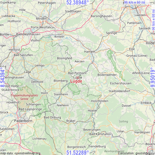
Lügde GPS coordinates[2]
51° 57' 29.808" North, 9° 14' 49.416" East
| Map corner | latitude | longitude |
|---|---|---|
| Upper-left | 52.38948°, | 8.54394° |
| Center: | 51.95828°, | 9.24706° |
| Lower-right: | 51.52289°, | 9.95019° |
| Map W x H: | 96.4×96.4 km | = 59.9×59.9mi |
| max Lat: | 55.01917° ⇑28.3% North |
| Lügde: | 51.95828° |
| min Lat: | ⇓71.7% South 47.40724° |
| min Long | Lügde | max Long |
| 5.92978° | 9.24706° | 14.98853° |
| W 38.4%⇐ | ⇒61.6% E |
Elevation
Elevation of Lügde is 106 m = 348 ft, and this is 143.1 m = 469 ft below average elevation for this country.
| Max E: |
1256 m = 4121 ft | 67.3% |
| Avg. | 249.1 m = 817 ft | |
| Lügde | 106 m = 348 ft | |
Min E: |
-5 m = -16 ft | 32.7% |
See also: Germany elevation on elevation.city.
Geographical zone
Lügde is located in North temperate zone (between Tropic of Cancer and the Arctic Circle). Distance of this North polar circle is 1624 km =1009.1 mi to North.| Distance of | km | miles | from Lügde |
|---|---|---|---|
| North Pole | 4229.8 | 2628.3 | to North |
| Arctic Circle | 1624 | 1009.1 | to North |
| Tropic Cancer | 3171.3 | 1970.6 | to South |
| Equator | 5777.2 | 3589.8 | to South |


Nearby cities:
15 places around Lügde: (largest is in red/bold)
• Aerzen
10.2 km =6.3 mi,  4°
4°
• Bad Pyrmont
3.1 km =1.9 mi,  6°
6°
• Barntrup
9.6 km =6 mi,  291°
291°
• Blomberg
10.8 km =6.7 mi,  261°
261°
• Brevörde
12.5 km =7.8 mi,  111°
111°
• Hameln
17.8 km =11.1 mi,  24°
24°
• Hehlen
15.6 km =9.7 mi,  77°
77°
• Heinsen
15.3 km =9.5 mi,  123°
123°
• Heyen
18.5 km =11.5 mi,  72°
72°
• Ottenstein
11 km =6.8 mi,  96°
96°
• Pegestorf
17.5 km =10.9 mi, 101°
• Polle
12.6 km =7.8 mi, 121°
• Schieder-Schwalenberg
9.7 km =6 mi,  201°
201°
• Steinheim
14.5 km =9 mi,  227°
227°
• Vahlbruch
7.6 km =4.7 mi, 123°
Sources, notices
• [Note1] Compared only with cities in Germany existing in our database
• [Src1] Map data: © OpenStreetMap contributors (CC-BY-SA)
• [Src2] Other city data from geonames.org with taken over terms of usage.
• [Src3] Geographical zone / Annual Mean Temperature by Robert A. Rohde @ Wikipedia
