Bockstadt geodata
Bockstadt (Thuringia) is a seat of a fourth-order administrative division; located in Germany in Europe/Berlin (GMT+2) time zone. With population of 308 people, there are 10026 cities with bigger population in this country. Compared to other cities in Germany, 54.7% of cities are located further ↑North; 65.2% of cities are located further ←West and 87.4% of cities have lower elevation than Bockstadt. Note1


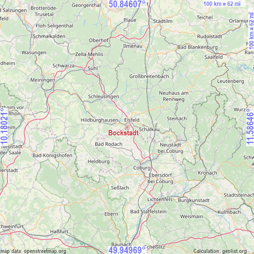
Bockstadt GPS coordinates[2]
50° 24' 0" North, 10° 52' 59.988" East
| Map corner | latitude | longitude |
|---|---|---|
| Upper-left | 50.84607°, | 10.18021° |
| Center: | 50.4°, | 10.88333° |
| Lower-right: | 49.94969°, | 11.58646° |
| Map W x H: | 99.7×99.7 km | = 62×62mi |
| max Lat: | 55.01917° ⇑54.7% North |
| Bockstadt: | 50.4° |
| min Lat: | ⇓45.3% South 47.40724° |
| min Long | Bockstadt | max Long |
| 5.92978° | 10.88333° | 14.98853° |
| W 65.2%⇐ | ⇒34.8% E |
Elevation
Elevation of Bockstadt is 489 m = 1604 ft, and this is 239.9 m = 787 ft above average elevation for this country.
| Max E: |
1256 m = 4121 ft | 12.6% |
| Bockstadt | 489 m 1604 ft | |
| Avg. | 249.1 m = 817 ft | |
Min E: |
-5 m = -16 ft | 87.4% |
See also: Germany elevation on elevation.city.
Geographical zone
Bockstadt is located in North temperate zone (between Tropic of Cancer and the Arctic Circle). Distance of this North polar circle is 1797.2 km =1116.7 mi to North.| Distance of | km | miles | from Bockstadt |
|---|---|---|---|
| North Pole | 4403.1 | 2736 | to North |
| Arctic Circle | 1797.2 | 1116.7 | to North |
| Tropic Cancer | 2998 | 1862.9 | to South |
| Equator | 5604 | 3482.2 | to South |


Nearby cities:
15 places around Bockstadt: (largest is in red/bold)
• Bachfeld
7.3 km =4.5 mi,  75°
75°
• Eisfeld
3.4 km =2.1 mi,  29°
29°
• Goldisthal
15.4 km =9.6 mi, 32°
• Hildburghausen
11.1 km =6.9 mi,  284°
284°
• Lautertal
9.5 km =5.9 mi,  141°
141°
• Masserberg
14.7 km =9.1 mi,  24°
24°
• Meeder
8.9 km =5.5 mi,  169°
169°
• Rödental
16.2 km =10.1 mi, 136°
• Sachsenbrunn
7 km =4.3 mi,  41°
41°
• Schalkau
8.8 km =5.5 mi,  93°
93°
• Scheibe-Alsbach
16 km =9.9 mi,  52°
52°
• Schleusingen
15.2 km =9.4 mi,  323°
323°
• Steinheid
15.9 km =9.9 mi,  62°
62°
• Veilsdorf
5.3 km =3.3 mi, 280°
• Weitramsdorf
16 km =9.9 mi,  180°
180°
Sources, notices
• [Note1] Compared only with cities in Germany existing in our database
• [Src1] Map data: © OpenStreetMap contributors (CC-BY-SA)
• [Src2] Other city data from geonames.org with taken over terms of usage.
• [Src3] Geographical zone / Annual Mean Temperature by Robert A. Rohde @ Wikipedia
