Bachfeld geodata
Bachfeld (Thuringia) is a seat of a fourth-order administrative division; located in Germany in Europe/Berlin (GMT+2) time zone. With population of 520 people, there are 9251 cities with bigger population in this country. Compared to other cities in Germany, 54.4% of cities are located further ↑North; 66.8% of cities are located further ←West and 81.4% of cities have lower elevation than Bachfeld. Note1


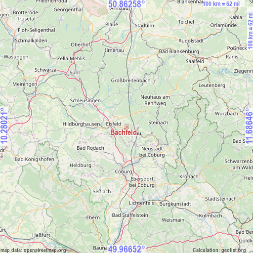
Bachfeld GPS coordinates[2]
50° 25' 0.012" North, 10° 58' 59.988" East
| Map corner | latitude | longitude |
|---|---|---|
| Upper-left | 50.86258°, | 10.28021° |
| Center: | 50.41667°, | 10.98333° |
| Lower-right: | 49.96652°, | 11.68646° |
| Map W x H: | 99.6×99.6 km | = 61.9×61.9mi |
| max Lat: | 55.01917° ⇑54.4% North |
| Bachfeld: | 50.41667° |
| min Lat: | ⇓45.6% South 47.40724° |
| min Long | Bachfeld | max Long |
| 5.92978° | 10.98333° | 14.98853° |
| W 66.8%⇐ | ⇒33.2% E |
Elevation
Elevation of Bachfeld is 443 m = 1453 ft, and this is 193.9 m = 636 ft above average elevation for this country.
| Max E: |
1256 m = 4121 ft | 18.6% |
| Bachfeld | 443 m 1453 ft | |
| Avg. | 249.1 m = 817 ft | |
Min E: |
-5 m = -16 ft | 81.4% |
See also: Germany elevation on elevation.city.
Geographical zone
Bachfeld is located in North temperate zone (between Tropic of Cancer and the Arctic Circle). Distance of this North polar circle is 1795.4 km =1115.6 mi to North.| Distance of | km | miles | from Bachfeld |
|---|---|---|---|
| North Pole | 4401.3 | 2734.8 | to North |
| Arctic Circle | 1795.4 | 1115.6 | to North |
| Tropic Cancer | 2999.9 | 1864.1 | to South |
| Equator | 5605.8 | 3483.3 | to South |


Nearby cities:
15 places around Bachfeld: (largest is in red/bold)
• Bockstadt
7.3 km =4.5 mi,  255°
255°
• Eisfeld
5.5 km =3.4 mi,  281°
281°
• Goldisthal
11.2 km =7 mi,  6°
6°
• Lautertal
9.3 km =5.8 mi,  187°
187°
• Masserberg
11.5 km =7.1 mi,  355°
355°
• Meeder
11.9 km =7.4 mi,  207°
207°
• Mengersgereuth-Hämmern
9.7 km =6 mi,  102°
102°
• Neustadt bei Coburg
13.7 km =8.5 mi,  134°
134°
• Rödental
14.1 km =8.8 mi,  163°
163°
• Sachsenbrunn
4.2 km =2.6 mi,  324°
324°
• Schalkau
2.9 km =1.8 mi,  144°
144°
• Scheibe-Alsbach
9.7 km =6 mi,  35°
35°
• Steinach
12.6 km =7.8 mi,  82°
82°
• Steinheid
8.9 km =5.5 mi,  52°
52°
• Veilsdorf
12.4 km =7.7 mi,  265°
265°
Sources, notices
• [Note1] Compared only with cities in Germany existing in our database
• [Src1] Map data: © OpenStreetMap contributors (CC-BY-SA)
• [Src2] Other city data from geonames.org with taken over terms of usage.
• [Src3] Geographical zone / Annual Mean Temperature by Robert A. Rohde @ Wikipedia
