Tønder geodata
Tønder (South Denmark) is a seat of a second-order administrative division; located in Denmark in Europe/Copenhagen (GMT+2) time zone. With population of 7,841 people, there are 94 cities with bigger population in this country. Compared to other cities in Denmark, 94.2% of cities are located further ↑North; 91.8% of cities are located further →East and 95.6% of cities have higher elevation than Tønder. Note1


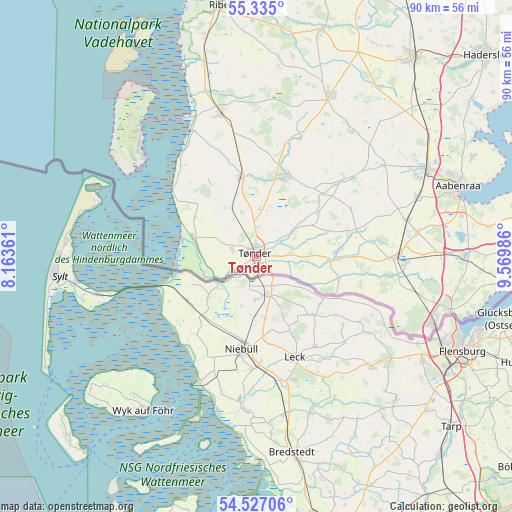
Tønder GPS coordinates[2]
54° 55' 59.016" North, 8° 52' 0.264" East
| Map corner | latitude | longitude |
|---|---|---|
| Upper-left | 55.335°, | 8.16361° |
| Center: | 54.93306°, | 8.86674° |
| Lower-right: | 54.52706°, | 9.56986° |
| Map W x H: | 89.8×89.8 km | = 55.8×55.8mi |
| max Lat: | 57.72093° ⇑94.2% North |
| Tønder: | 54.93306° |
| min Lat: | ⇓5.8% South 54.57644° |
| min Long | Tønder | max Long |
| 8.12605° | 8.86674° | 15.18662° |
| W 8.2%⇐ | ⇒91.8% E |
Elevation
Elevation of Tønder is 3 m = 10 ft, and this is 24.3 m = 80 ft below average elevation for this country.
| Max E: |
114 m = 374 ft | 95.6% |
| Avg. | 27.3 m = 90 ft | |
| Tønder | 3 m = 10 ft | |
Min E: |
0 m = 0 ft | 4.4% |
See also: Denmark elevation on elevation.city.
Geographical zone
Tønder is located in North temperate zone (between Tropic of Cancer and the Arctic Circle). Distance of this North polar circle is 1293.2 km =803.6 mi to North.| Distance of | km | miles | from Tønder |
|---|---|---|---|
| North Pole | 3899.1 | 2422.8 | to North |
| Arctic Circle | 1293.2 | 803.6 | to North |
| Tropic Cancer | 3502.1 | 2176.1 | to South |
| Equator | 6108 | 3795.3 | to South |


Nearby cities:
15 places around Tønder: (largest is in red/bold)
• Aabenraa
37.2 km =23.1 mi,  70°
70°
• Broager
51.9 km =32.2 mi,  95°
95°
• Gram
41.3 km =25.7 mi,  16°
16°
• Gråsten
46.6 km =29 mi,  91°
91°
• Kruså
35.4 km =22 mi, 104°
• Løgumkloster
15.1 km =9.4 mi, 21°
• Løjt Kirkeby
41.7 km =25.9 mi, 65°
• Padborg
33.8 km =21 mi,  110°
110°
• Ribe
44.6 km =27.7 mi,  352°
352°
• Rødding
49.7 km =30.9 mi,  14°
14°
• Rødekro
33.6 km =20.9 mi,  62°
62°
• Skaerbaek
25.7 km =16 mi, 345°
• Tinglev
24.8 km =15.4 mi, 88°
• Toftlund
31.2 km =19.4 mi, 24°
• Vojens
44.7 km =27.8 mi,  38°
38°
Sources, notices
• [Note1] Compared only with cities in Denmark existing in our database
• [Src1] Map data: © OpenStreetMap contributors (CC-BY-SA)
• [Src2] Other city data from geonames.org with taken over terms of usage.
• [Src3] Geographical zone / Annual Mean Temperature by Robert A. Rohde @ Wikipedia
