Skaerbaek geodata
Skaerbaek (South Denmark) is a populated place; located in Denmark in Europe/Copenhagen (GMT+2) time zone. With population of 3,174 people, there are 198 cities with bigger population in this country. Compared to other cities in Denmark, 87.1% of cities are located further ↑North; 93.6% of cities are located further →East and 59.6% of cities have higher elevation than Skaerbaek. Note1


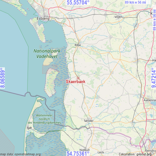
Skaerbaek GPS coordinates[2]
55° 9' 26.46" North, 8° 46' 8.436" East
| Map corner | latitude | longitude |
|---|---|---|
| Upper-left | 55.55704°, | 8.06589° |
| Center: | 55.15735°, | 8.76901° |
| Lower-right: | 54.75361°, | 9.47214° |
| Map W x H: | 89.3×89.3 km | = 55.5×55.5mi |
| max Lat: | 57.72093° ⇑87.1% North |
| Skaerbaek: | 55.15735° |
| min Lat: | ⇓12.9% South 54.57644° |
| min Long | Skaerbaek | max Long |
| 8.12605° | 8.76901° | 15.18662° |
| W 6.4%⇐ | ⇒93.6% E |
Elevation
Elevation of Skaerbaek is 16 m = 52 ft, and this is 11.3 m = 37 ft below average elevation for this country.
| Max E: |
114 m = 374 ft | 59.6% |
| Avg. | 27.3 m = 90 ft | |
| Skaerbaek | 16 m = 52 ft | |
Min E: |
0 m = 0 ft | 40.4% |
See also: Denmark elevation on elevation.city.
Geographical zone
Skaerbaek is located in North temperate zone (between Tropic of Cancer and the Arctic Circle). Distance of this North polar circle is 1268.3 km =788.1 mi to North.| Distance of | km | miles | from Skaerbaek |
|---|---|---|---|
| North Pole | 3874.1 | 2407.3 | to North |
| Arctic Circle | 1268.3 | 788.1 | to North |
| Tropic Cancer | 3527 | 2191.6 | to South |
| Equator | 6132.9 | 3810.8 | to South |


Nearby cities:
15 places around Skaerbaek: (largest is in red/bold)
• Bramming
35 km =21.7 mi,  352°
352°
• Brørup
39.4 km =24.5 mi,  23°
23°
• Esbjerg
40.2 km =25 mi,  330°
330°
• Gram
23.1 km =14.4 mi,  50°
50°
• Holsted
40.4 km =25.1 mi,  13°
13°
• Løgumkloster
16.1 km =10 mi,  132°
132°
• Nordby
39.8 km =24.7 mi,  323°
323°
• Ribe
19.3 km =12 mi,  0°
0°
• Rødding
29.7 km =18.5 mi,  38°
38°
• Rødekro
37.3 km =23.2 mi,  104°
104°
• Tinglev
39.4 km =24.5 mi, 128°
• Tjæreborg
36.2 km =22.5 mi,  340°
340°
• Toftlund
19.4 km =12.1 mi,  79°
79°
• Tønder
25.7 km =16 mi,  165°
165°
• Vojens
35.5 km =22.1 mi,  73°
73°
Sources, notices
• [Note1] Compared only with cities in Denmark existing in our database
• [Src1] Map data: © OpenStreetMap contributors (CC-BY-SA)
• [Src2] Other city data from geonames.org with taken over terms of usage.
• [Src3] Geographical zone / Annual Mean Temperature by Robert A. Rohde @ Wikipedia
