Rødding geodata
Rødding (South Denmark) is a populated place; located in Denmark in Europe/Copenhagen (GMT+2) time zone. With population of 2,769 people, there are 229 cities with bigger population in this country. Compared to other cities in Denmark, 77.2% of cities are located further ↑North; 88% of cities are located further →East and 67.8% of cities have lower elevation than Rødding. Note1


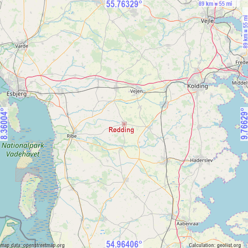
Rødding GPS coordinates[2]
55° 21' 56.484" North, 9° 3' 47.376" East
| Map corner | latitude | longitude |
|---|---|---|
| Upper-left | 55.76329°, | 8.36004° |
| Center: | 55.36569°, | 9.06316° |
| Lower-right: | 54.96406°, | 9.76629° |
| Map W x H: | 88.9×88.9 km | = 55.2×55.2mi |
| max Lat: | 57.72093° ⇑77.2% North |
| Rødding: | 55.36569° |
| min Lat: | ⇓22.8% South 54.57644° |
| min Long | Rødding | max Long |
| 8.12605° | 9.06316° | 15.18662° |
| W 12%⇐ | ⇒88% E |
Elevation
Elevation of Rødding is 35 m = 115 ft, and this is 7.7 m = 25 ft above average elevation for this country.
| Max E: |
114 m = 374 ft | 32.2% |
| Rødding | 35 m 115 ft | |
| Avg. | 27.3 m = 90 ft | |
Min E: |
0 m = 0 ft | 67.8% |
See also: Denmark elevation on elevation.city.
Geographical zone
Rødding is located in North temperate zone (between Tropic of Cancer and the Arctic Circle). Distance of this North polar circle is 1245.1 km =773.7 mi to North.| Distance of | km | miles | from Rødding |
|---|---|---|---|
| North Pole | 3851 | 2392.9 | to North |
| Arctic Circle | 1245.1 | 773.7 | to North |
| Tropic Cancer | 3550.2 | 2206 | to South |
| Equator | 6156.1 | 3825.2 | to South |


Nearby cities:
15 places around Rødding: (largest is in red/bold)
• Bramming
25.7 km =16 mi,  296°
296°
• Brørup
13.2 km =8.2 mi,  347°
347°
• Christiansfeld
26.8 km =16.7 mi,  91°
91°
• Egtved
31.8 km =19.8 mi,  28°
28°
• Gram
8.5 km =5.3 mi,  185°
185°
• Haderslev
29.8 km =18.5 mi,  115°
115°
• Holsted
18.5 km =11.5 mi,  330°
330°
• Kolding
29.3 km =18.2 mi,  61°
61°
• Lunderskov
19.9 km =12.4 mi,  48°
48°
• Ribe
19 km =11.8 mi,  258°
258°
• Skaerbaek
29.7 km =18.5 mi,  218°
218°
• Toftlund
19.7 km =12.2 mi,  178°
178°
• Vamdrup
15.6 km =9.7 mi, 63°
• Vejen
13.7 km =8.5 mi,  20°
20°
• Vojens
20.3 km =12.6 mi,  130°
130°
Sources, notices
• [Note1] Compared only with cities in Denmark existing in our database
• [Src1] Map data: © OpenStreetMap contributors (CC-BY-SA)
• [Src2] Other city data from geonames.org with taken over terms of usage.
• [Src3] Geographical zone / Annual Mean Temperature by Robert A. Rohde @ Wikipedia
