Gram geodata
Gram (South Denmark) is a populated place; located in Denmark in Europe/Copenhagen (GMT+2) time zone. With population of 2,548 people, there are 246 cities with bigger population in this country. Compared to other cities in Denmark, 82.5% of cities are located further ↑North; 88.9% of cities are located further →East and 68.7% of cities have lower elevation than Gram. Note1


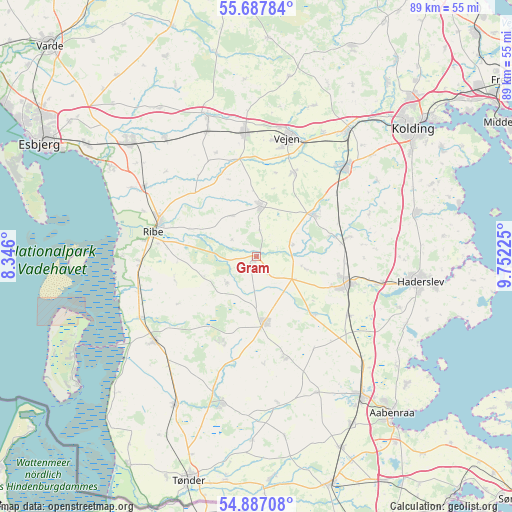
Gram GPS coordinates[2]
55° 17' 22.128" North, 9° 2' 56.868" East
| Map corner | latitude | longitude |
|---|---|---|
| Upper-left | 55.68784°, | 8.346° |
| Center: | 55.28948°, | 9.04913° |
| Lower-right: | 54.88708°, | 9.75225° |
| Map W x H: | 89×89 km | = 55.3×55.3mi |
| max Lat: | 57.72093° ⇑82.5% North |
| Gram: | 55.28948° |
| min Lat: | ⇓17.5% South 54.57644° |
| min Long | Gram | max Long |
| 8.12605° | 9.04913° | 15.18662° |
| W 11.1%⇐ | ⇒88.9% E |
Elevation
Elevation of Gram is 36 m = 118 ft, and this is 8.7 m = 29 ft above average elevation for this country.
| Max E: |
114 m = 374 ft | 31.3% |
| Gram | 36 m 118 ft | |
| Avg. | 27.3 m = 90 ft | |
Min E: |
0 m = 0 ft | 68.7% |
See also: Denmark elevation on elevation.city.
Geographical zone
Gram is located in North temperate zone (between Tropic of Cancer and the Arctic Circle). Distance of this North polar circle is 1253.6 km =779 mi to North.| Distance of | km | miles | from Gram |
|---|---|---|---|
| North Pole | 3859.4 | 2398.1 | to North |
| Arctic Circle | 1253.6 | 779 | to North |
| Tropic Cancer | 3541.7 | 2200.7 | to South |
| Equator | 6147.6 | 3819.9 | to South |


Nearby cities:
15 places around Gram: (largest is in red/bold)
• Bramming
29.8 km =18.5 mi,  312°
312°
• Brørup
21.5 km =13.4 mi,  354°
354°
• Christiansfeld
28.7 km =17.8 mi,  74°
74°
• Haderslev
28.1 km =17.5 mi,  99°
99°
• Holsted
26 km =16.2 mi,  341°
341°
• Lunderskov
26.8 km =16.7 mi,  36°
36°
• Løgumkloster
26.3 km =16.3 mi,  193°
193°
• Ribe
18.3 km =11.4 mi,  284°
284°
• Rødding
8.5 km =5.3 mi,  5°
5°
• Rødekro
30.4 km =18.9 mi,  143°
143°
• Skaerbaek
23.1 km =14.4 mi,  230°
230°
• Toftlund
11.3 km =7 mi,  173°
173°
• Vamdrup
21.4 km =13.3 mi, 44°
• Vejen
22 km =13.7 mi, 14°
• Vojens
17 km =10.6 mi,  106°
106°
Sources, notices
• [Note1] Compared only with cities in Denmark existing in our database
• [Src1] Map data: © OpenStreetMap contributors (CC-BY-SA)
• [Src2] Other city data from geonames.org with taken over terms of usage.
• [Src3] Geographical zone / Annual Mean Temperature by Robert A. Rohde @ Wikipedia
