Søndersø geodata
Søndersø (South Denmark) is a populated place; located in Denmark in Europe/Copenhagen (GMT+2) time zone. With population of 2,850 people, there are 221 cities with bigger population in this country. Compared to other cities in Denmark, 68.4% of cities are located further ↑North; 50.3% of cities are located further ←West and 60.8% of cities have lower elevation than Søndersø. Note1


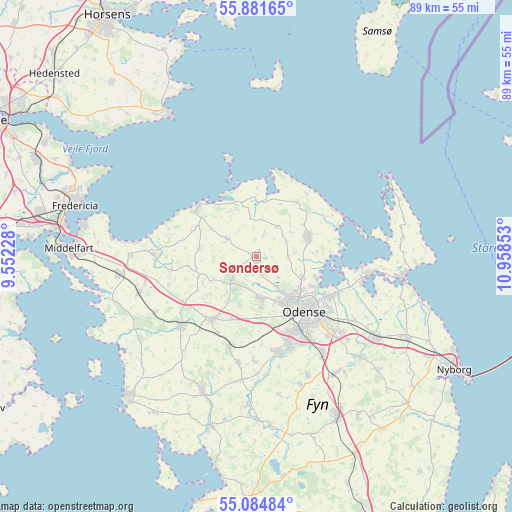
Søndersø GPS coordinates[2]
55° 29' 6.936" North, 10° 15' 19.44" East
| Map corner | latitude | longitude |
|---|---|---|
| Upper-left | 55.88165°, | 9.55228° |
| Center: | 55.48526°, | 10.2554° |
| Lower-right: | 55.08484°, | 10.95853° |
| Map W x H: | 88.6×88.6 km | = 55.1×55.1mi |
| max Lat: | 57.72093° ⇑68.4% North |
| Søndersø: | 55.48526° |
| min Lat: | ⇓31.6% South 54.57644° |
| min Long | Søndersø | max Long |
| 8.12605° | 10.2554° | 15.18662° |
| W 50.3%⇐ | ⇒49.7% E |
Elevation
Elevation of Søndersø is 30 m = 98 ft, and this is 2.7 m = 9 ft above average elevation for this country.
| Max E: |
114 m = 374 ft | 39.2% |
| Søndersø | 30 m 98 ft | |
| Avg. | 27.3 m = 90 ft | |
Min E: |
0 m = 0 ft | 60.8% |
See also: Denmark elevation on elevation.city.
Geographical zone
Søndersø is located in North temperate zone (between Tropic of Cancer and the Arctic Circle). Distance of this North polar circle is 1231.8 km =765.4 mi to North.| Distance of | km | miles | from Søndersø |
|---|---|---|---|
| North Pole | 3837.7 | 2384.6 | to North |
| Arctic Circle | 1231.8 | 765.4 | to North |
| Tropic Cancer | 3563.5 | 2214.3 | to South |
| Equator | 6169.4 | 3833.5 | to South |


Nearby cities:
15 places around Søndersø: (largest is in red/bold)
• Bellinge
17.2 km =10.7 mi,  166°
166°
• Bogense
13.9 km =8.6 mi,  310°
310°
• Brenderup
17.4 km =10.8 mi,  269°
269°
• Bullerup
15.1 km =9.4 mi,  115°
115°
• Harndrup
14.9 km =9.3 mi,  261°
261°
• Munkebo
19.1 km =11.9 mi,  99°
99°
• Neder Holluf
18.1 km =11.2 mi,  137°
137°
• Odense
13 km =8.1 mi, 139°
• Otterup
9.6 km =6 mi,  69°
69°
• Seden
13.5 km =8.4 mi, 118°
• Stige
11 km =6.8 mi, 117°
• Tommerup
18.7 km =11.6 mi,  189°
189°
• Tommerup Stationsby
16.3 km =10.1 mi,  197°
197°
• Vissenbjerg
13.4 km =8.3 mi,  213°
213°
• Årup
18.4 km =11.4 mi,  227°
227°
Sources, notices
• [Note1] Compared only with cities in Denmark existing in our database
• [Src1] Map data: © OpenStreetMap contributors (CC-BY-SA)
• [Src2] Other city data from geonames.org with taken over terms of usage.
• [Src3] Geographical zone / Annual Mean Temperature by Robert A. Rohde @ Wikipedia
