Odense geodata
Odense (South Denmark) is a seat of a second-order administrative division; located in Denmark in Europe/Copenhagen (GMT+2) time zone. With population of 145,931 people, there are 2 cities with bigger population in this country. Compared to other cities in Denmark, 76% of cities are located further ↑North; 52.9% of cities are located further ←West and 56.1% of cities have higher elevation than Odense. Note1


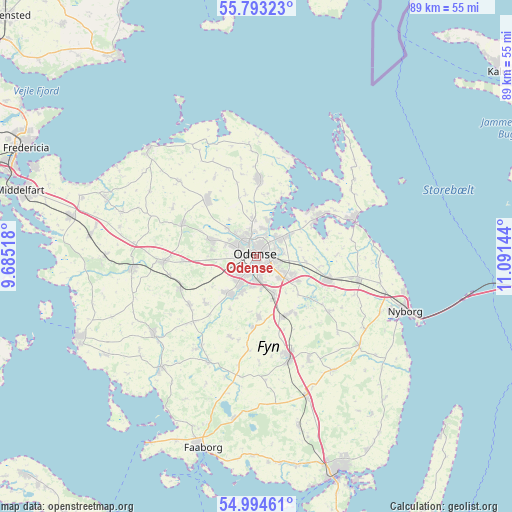
Odense GPS coordinates[2]
55° 23' 45.384" North, 10° 23' 17.916" East
| Map corner | latitude | longitude |
|---|---|---|
| Upper-left | 55.79323°, | 9.68518° |
| Center: | 55.39594°, | 10.38831° |
| Lower-right: | 54.99461°, | 11.09144° |
| Map W x H: | 88.8×88.8 km | = 55.2×55.2mi |
| max Lat: | 57.72093° ⇑76% North |
| Odense: | 55.39594° |
| min Lat: | ⇓24% South 54.57644° |
| min Long | Odense | max Long |
| 8.12605° | 10.38831° | 15.18662° |
| W 52.9%⇐ | ⇒47.1% E |
Elevation
Elevation of Odense is 17 m = 56 ft, and this is 10.3 m = 34 ft below average elevation for this country.
| Max E: |
114 m = 374 ft | 56.1% |
| Avg. | 27.3 m = 90 ft | |
| Odense | 17 m = 56 ft | |
Min E: |
0 m = 0 ft | 43.9% |
See also: Odense elevation on elevation.city.
Geographical zone
Odense is located in North temperate zone (between Tropic of Cancer and the Arctic Circle). Distance of this North polar circle is 1241.7 km =771.6 mi to North.| Distance of | km | miles | from Odense |
|---|---|---|---|
| North Pole | 3847.6 | 2390.8 | to North |
| Arctic Circle | 1241.7 | 771.6 | to North |
| Tropic Cancer | 3553.5 | 2208 | to South |
| Equator | 6159.5 | 3827.3 | to South |


Nearby cities:
15 places around Odense: (largest is in red/bold)
• Bellinge
8 km =5 mi,  212°
212°
• Bullerup
6.3 km =3.9 mi,  56°
56°
• Højby
7.8 km =4.8 mi,  156°
156°
• Langeskov
13.1 km =8.1 mi,  109°
109°
• Munkebo
12.4 km =7.7 mi, 57°
• Neder Holluf
5.2 km =3.2 mi,  132°
132°
• Otterup
13.3 km =8.3 mi,  2°
2°
• Seden
4.8 km =3 mi,  45°
45°
• Stige
5 km =3.1 mi,  15°
15°
• Søndersø
13 km =8.1 mi,  319°
319°
• Tommerup
14.3 km =8.9 mi,  233°
233°
• Tommerup Stationsby
14.5 km =9 mi,  247°
247°
• Ullerslev
17.1 km =10.6 mi,  102°
102°
• Vissenbjerg
15.9 km =9.9 mi,  265°
265°
• Årslev
11.3 km =7 mi,  154°
154°
Sources, notices
• [Note1] Compared only with cities in Denmark existing in our database
• [Src1] Map data: © OpenStreetMap contributors (CC-BY-SA)
• [Src2] Other city data from geonames.org with taken over terms of usage.
• [Src3] Geographical zone / Annual Mean Temperature by Robert A. Rohde @ Wikipedia
