Vissenbjerg geodata
Vissenbjerg (South Denmark) is a populated place; located in Denmark in Europe/Copenhagen (GMT+2) time zone. With population of 3,055 people, there are 210 cities with bigger population in this country. Compared to other cities in Denmark, 76.3% of cities are located further ↑North; 53.8% of cities are located further →East and 100% of cities have lower elevation than Vissenbjerg. Note1


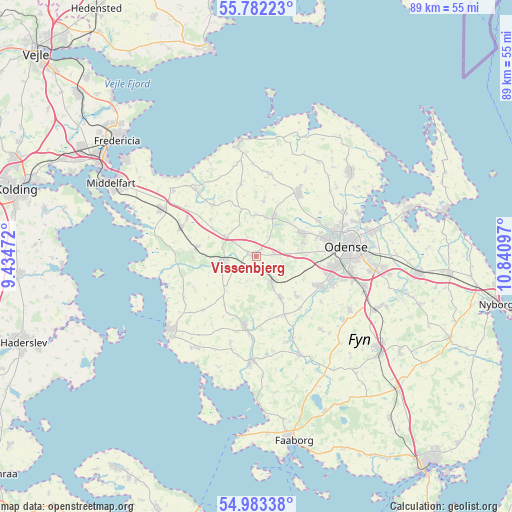
Vissenbjerg GPS coordinates[2]
55° 23' 5.352" North, 10° 8' 16.224" East
| Map corner | latitude | longitude |
|---|---|---|
| Upper-left | 55.78223°, | 9.43472° |
| Center: | 55.38482°, | 10.13784° |
| Lower-right: | 54.98338°, | 10.84097° |
| Map W x H: | 88.8×88.8 km | = 55.2×55.2mi |
| max Lat: | 57.72093° ⇑76.3% North |
| Vissenbjerg: | 55.38482° |
| min Lat: | ⇓23.7% South 54.57644° |
| min Long | Vissenbjerg | max Long |
| 8.12605° | 10.13784° | 15.18662° |
| W 46.2%⇐ | ⇒53.8% E |
Elevation
Elevation of Vissenbjerg is 114 m = 374 ft, and this is 86.7 m = 284 ft above average elevation for this country.
| Max E: |
114 m = 374 ft | 0% |
| Vissenbjerg | 114 m 374 ft | |
| Avg. | 27.3 m = 90 ft | |
Min E: |
0 m = 0 ft | 100% |
See also: Denmark elevation on elevation.city.
Geographical zone
Vissenbjerg is located in North temperate zone (between Tropic of Cancer and the Arctic Circle). Distance of this North polar circle is 1243 km =772.4 mi to North.| Distance of | km | miles | from Vissenbjerg |
|---|---|---|---|
| North Pole | 3848.8 | 2391.5 | to North |
| Arctic Circle | 1243 | 772.4 | to North |
| Tropic Cancer | 3552.3 | 2207.3 | to South |
| Equator | 6158.2 | 3826.5 | to South |


Nearby cities:
15 places around Vissenbjerg: (largest is in red/bold)
• Assens
19.7 km =12.2 mi,  229°
229°
• Bellinge
12.8 km =8 mi,  115°
115°
• Brenderup
14.9 km =9.3 mi,  317°
317°
• Ejby
14.1 km =8.8 mi,  290°
290°
• Glamsbjerg
12.7 km =7.9 mi,  189°
189°
• Harndrup
11.7 km =7.3 mi, 321°
• Hårby
18 km =11.2 mi,  183°
183°
• Neder Holluf
19.7 km =12.2 mi,  96°
96°
• Nørre Åby
18.4 km =11.4 mi,  297°
297°
• Odense
15.9 km =9.9 mi,  85°
85°
• Stige
18.2 km =11.3 mi,  70°
70°
• Søndersø
13.4 km =8.3 mi,  33°
33°
• Tommerup
8.5 km =5.3 mi,  149°
149°
• Tommerup Stationsby
5 km =3.1 mi, 151°
• Årup
6.2 km =3.9 mi,  257°
257°
Sources, notices
• [Note1] Compared only with cities in Denmark existing in our database
• [Src1] Map data: © OpenStreetMap contributors (CC-BY-SA)
• [Src2] Other city data from geonames.org with taken over terms of usage.
• [Src3] Geographical zone / Annual Mean Temperature by Robert A. Rohde @ Wikipedia
