Bogense geodata
Bogense (South Denmark) is a seat of a second-order administrative division; located in Denmark in Europe/Copenhagen (GMT+2) time zone. With population of 3,410 people, there are 186 cities with bigger population in this country. Compared to other cities in Denmark, 62.6% of cities are located further ↑North; 56.4% of cities are located further →East and 77.2% of cities have higher elevation than Bogense. Note1


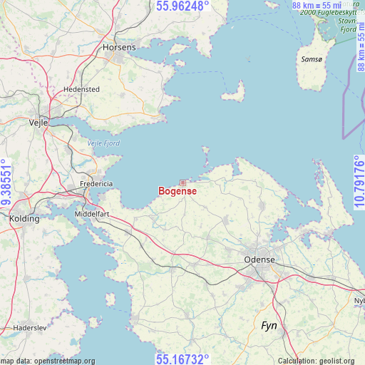
Bogense GPS coordinates[2]
55° 34' 0.876" North, 10° 5' 19.068" East
| Map corner | latitude | longitude |
|---|---|---|
| Upper-left | 55.96248°, | 9.38551° |
| Center: | 55.56691°, | 10.08863° |
| Lower-right: | 55.16732°, | 10.79176° |
| Map W x H: | 88.4×88.4 km | = 54.9×54.9mi |
| max Lat: | 57.72093° ⇑62.6% North |
| Bogense: | 55.56691° |
| min Lat: | ⇓37.4% South 54.57644° |
| min Long | Bogense | max Long |
| 8.12605° | 10.08863° | 15.18662° |
| W 43.6%⇐ | ⇒56.4% E |
Elevation
Elevation of Bogense is 10 m = 33 ft, and this is 17.3 m = 57 ft below average elevation for this country.
| Max E: |
114 m = 374 ft | 77.2% |
| Avg. | 27.3 m = 90 ft | |
| Bogense | 10 m = 33 ft | |
Min E: |
0 m = 0 ft | 22.8% |
See also: Denmark elevation on elevation.city.
Geographical zone
Bogense is located in North temperate zone (between Tropic of Cancer and the Arctic Circle). Distance of this North polar circle is 1222.7 km =759.8 mi to North.| Distance of | km | miles | from Bogense |
|---|---|---|---|
| North Pole | 3828.6 | 2379 | to North |
| Arctic Circle | 1222.7 | 759.8 | to North |
| Tropic Cancer | 3572.5 | 2219.8 | to South |
| Equator | 6178.5 | 3839.1 | to South |


Nearby cities:
15 places around Bogense: (largest is in red/bold)
• Brenderup
11.5 km =7.1 mi,  216°
216°
• Ejby
18.2 km =11.3 mi,  213°
213°
• Fredericia
21.1 km =13.1 mi,  269°
269°
• Harndrup
11.9 km =7.4 mi,  200°
200°
• Juelsminde
16.4 km =10.2 mi,  344°
344°
• Middelfart
23.5 km =14.6 mi,  253°
253°
• Nørre Åby
17.7 km =11 mi,  228°
228°
• Otterup
20.3 km =12.6 mi,  106°
106°
• Snoghøj
23.6 km =14.7 mi,  257°
257°
• Stige
24.7 km =15.3 mi,  125°
125°
• Strib
20.4 km =12.7 mi, 261°
• Søndersø
13.9 km =8.6 mi, 130°
• Tommerup Stationsby
25.2 km =15.7 mi,  167°
167°
• Vissenbjerg
20.5 km =12.7 mi, 171°
• Årup
21.7 km =13.5 mi,  187°
187°
Sources, notices
• [Note1] Compared only with cities in Denmark existing in our database
• [Src1] Map data: © OpenStreetMap contributors (CC-BY-SA)
• [Src2] Other city data from geonames.org with taken over terms of usage.
• [Src3] Geographical zone / Annual Mean Temperature by Robert A. Rohde @ Wikipedia
