Bullerup geodata
Bullerup (South Denmark) is a populated place; located in Denmark in Europe/Copenhagen (GMT+2) time zone. With population of 2,982 people, there are 213 cities with bigger population in this country. Compared to other cities in Denmark, 74.6% of cities are located further ↑North; 55.6% of cities are located further ←West and 95.6% of cities have higher elevation than Bullerup. Note1


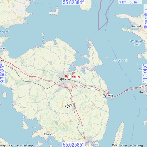
Bullerup GPS coordinates[2]
55° 25' 36.696" North, 10° 28' 16.932" East
| Map corner | latitude | longitude |
|---|---|---|
| Upper-left | 55.82384°, | 9.76825° |
| Center: | 55.42686°, | 10.47137° |
| Lower-right: | 55.02585°, | 11.1745° |
| Map W x H: | 88.7×88.7 km | = 55.1×55.1mi |
| max Lat: | 57.72093° ⇑74.6% North |
| Bullerup: | 55.42686° |
| min Lat: | ⇓25.4% South 54.57644° |
| min Long | Bullerup | max Long |
| 8.12605° | 10.47137° | 15.18662° |
| W 55.6%⇐ | ⇒44.4% E |
Elevation
Elevation of Bullerup is 3 m = 10 ft, and this is 24.3 m = 80 ft below average elevation for this country.
| Max E: |
114 m = 374 ft | 95.6% |
| Avg. | 27.3 m = 90 ft | |
| Bullerup | 3 m = 10 ft | |
Min E: |
0 m = 0 ft | 4.4% |
See also: Denmark elevation on elevation.city.
Geographical zone
Bullerup is located in North temperate zone (between Tropic of Cancer and the Arctic Circle). Distance of this North polar circle is 1238.3 km =769.4 mi to North.| Distance of | km | miles | from Bullerup |
|---|---|---|---|
| North Pole | 3844.2 | 2388.7 | to North |
| Arctic Circle | 1238.3 | 769.4 | to North |
| Tropic Cancer | 3557 | 2210.2 | to South |
| Equator | 6162.9 | 3829.4 | to South |


Nearby cities:
15 places around Bullerup: (largest is in red/bold)
• Bellinge
13.9 km =8.6 mi,  223°
223°
• Højby
10.8 km =6.7 mi,  191°
191°
• Kerteminde
12 km =7.5 mi,  78°
78°
• Langeskov
10.6 km =6.6 mi,  137°
137°
• Munkebo
6.1 km =3.8 mi,  58°
58°
• Neder Holluf
7.1 km =4.4 mi, 191°
• Odense
6.3 km =3.9 mi,  236°
236°
• Otterup
10.9 km =6.8 mi,  334°
334°
• Seden
1.8 km =1.1 mi,  268°
268°
• Stige
4.2 km =2.6 mi,  289°
289°
• Søndersø
15.1 km =9.4 mi,  295°
295°
• Tommerup
20.6 km =12.8 mi,  234°
234°
• Tommerup Stationsby
20.7 km =12.9 mi, 244°
• Ullerslev
13.5 km =8.4 mi,  122°
122°
• Årslev
13.7 km =8.5 mi,  181°
181°
Sources, notices
• [Note1] Compared only with cities in Denmark existing in our database
• [Src1] Map data: © OpenStreetMap contributors (CC-BY-SA)
• [Src2] Other city data from geonames.org with taken over terms of usage.
• [Src3] Geographical zone / Annual Mean Temperature by Robert A. Rohde @ Wikipedia
