Brenderup geodata
Brenderup (South Denmark) is a populated place; located in Denmark in Europe/Copenhagen (GMT+2) time zone. With population of 1,366 people, there are 327 cities with bigger population in this country. Compared to other cities in Denmark, 68.7% of cities are located further ↑North; 62% of cities are located further →East and 74.3% of cities have higher elevation than Brenderup. Note1


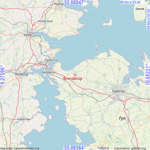
Brenderup GPS coordinates[2]
55° 29' 2.652" North, 9° 58' 44.688" East
| Map corner | latitude | longitude |
|---|---|---|
| Upper-left | 55.88047°, | 9.27596° |
| Center: | 55.48407°, | 9.97908° |
| Lower-right: | 55.08364°, | 10.68221° |
| Map W x H: | 88.6×88.6 km | = 55.1×55.1mi |
| max Lat: | 57.72093° ⇑68.7% North |
| Brenderup: | 55.48407° |
| min Lat: | ⇓31.3% South 54.57644° |
| min Long | Brenderup | max Long |
| 8.12605° | 9.97908° | 15.18662° |
| W 38%⇐ | ⇒62% E |
Elevation
Elevation of Brenderup is 11 m = 36 ft, and this is 16.3 m = 53 ft below average elevation for this country.
| Max E: |
114 m = 374 ft | 74.3% |
| Avg. | 27.3 m = 90 ft | |
| Brenderup | 11 m = 36 ft | |
Min E: |
0 m = 0 ft | 25.7% |
See also: Denmark elevation on elevation.city.
Geographical zone
Brenderup is located in North temperate zone (between Tropic of Cancer and the Arctic Circle). Distance of this North polar circle is 1231.9 km =765.5 mi to North.| Distance of | km | miles | from Brenderup |
|---|---|---|---|
| North Pole | 3837.8 | 2384.7 | to North |
| Arctic Circle | 1231.9 | 765.5 | to North |
| Tropic Cancer | 3563.3 | 2214.1 | to South |
| Equator | 6169.3 | 3833.4 | to South |


Nearby cities:
15 places around Brenderup: (largest is in red/bold)
• Assens
24.3 km =15.1 mi,  191°
191°
• Bogense
11.5 km =7.1 mi,  36°
36°
• Ejby
6.8 km =4.2 mi,  207°
207°
• Fredericia
16.9 km =10.5 mi,  302°
302°
• Harndrup
3.3 km =2.1 mi,  125°
125°
• Middelfart
15.8 km =9.8 mi,  278°
278°
• Nørre Åby
6.8 km =4.2 mi,  247°
247°
• Snoghøj
16.8 km =10.4 mi, 284°
• Strib
14.7 km =9.1 mi, 295°
• Søndersø
17.4 km =10.8 mi,  89°
89°
• Taulov
23.9 km =14.9 mi,  286°
286°
• Tommerup
23.3 km =14.5 mi,  141°
141°
• Tommerup Stationsby
19.8 km =12.3 mi, 141°
• Vissenbjerg
14.9 km =9.3 mi, 137°
• Årup
12.9 km =8 mi,  162°
162°
Sources, notices
• [Note1] Compared only with cities in Denmark existing in our database
• [Src1] Map data: © OpenStreetMap contributors (CC-BY-SA)
• [Src2] Other city data from geonames.org with taken over terms of usage.
• [Src3] Geographical zone / Annual Mean Temperature by Robert A. Rohde @ Wikipedia
