Rønne geodata
Rønne (Capital Region) is a seat of a second-order administrative division; located in Denmark in Europe/Copenhagen (GMT+2) time zone. With population of 13,890 people, there are 55 cities with bigger population in this country. Compared to other cities in Denmark, 87.7% of cities are located further ↑North; 99.1% of cities are located further ←West and 50.3% of cities have lower elevation than Rønne. Note1


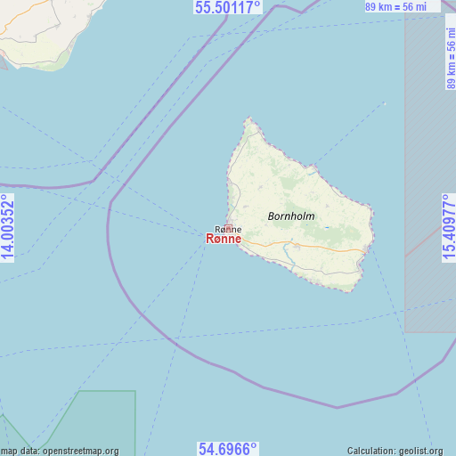
Rønne GPS coordinates[2]
55° 6' 3.276" North, 14° 42' 23.904" East
| Map corner | latitude | longitude |
|---|---|---|
| Upper-left | 55.50117°, | 14.00352° |
| Center: | 55.10091°, | 14.70664° |
| Lower-right: | 54.6966°, | 15.40977° |
| Map W x H: | 89.5×89.5 km | = 55.6×55.6mi |
| max Lat: | 57.72093° ⇑87.7% North |
| Rønne: | 55.10091° |
| min Lat: | ⇓12.3% South 54.57644° |
| min Long | Rønne | max Long |
| 8.12605° | 14.70664° | 15.18662° |
| W 99.1%⇐ | ⇒0.90000000000001% E |
Elevation
Elevation of Rønne is 22 m = 72 ft, and this is 5.3 m = 17 ft below average elevation for this country.
| Max E: |
114 m = 374 ft | 49.7% |
| Avg. | 27.3 m = 90 ft | |
| Rønne | 22 m = 72 ft | |
Min E: |
0 m = 0 ft | 50.3% |
See also: Denmark elevation on elevation.city.
Geographical zone
Rønne is located in North temperate zone (between Tropic of Cancer and the Arctic Circle). Distance of this North polar circle is 1274.5 km =791.9 mi to North.| Distance of | km | miles | from Rønne |
|---|---|---|---|
| North Pole | 3880.4 | 2411.2 | to North |
| Arctic Circle | 1274.5 | 791.9 | to North |
| Tropic Cancer | 3520.7 | 2187.7 | to South |
| Equator | 6126.6 | 3806.9 | to South |


Nearby cities:
15 places around Rønne: (largest is in red/bold)
• Charlottenlund
152.8 km =94.9 mi,  298°
298°
• Christianshavn
147.8 km =91.8 mi, 295°
• Christiansø
39 km =24.2 mi,  51°
51°
• Copenhagen
149.6 km =93 mi, 295°
• Dragør
139.8 km =86.9 mi,  293°
293°
• Frederiksberg
151.5 km =94.1 mi, 295°
• Hvidovre
154 km =95.7 mi, 293°
• Nexø
27.4 km =17 mi,  99°
99°
• Rødvig
148.8 km =92.5 mi,  276°
276°
• Stege
154.8 km =96.2 mi,  265°
265°
• Store Heddinge
148.9 km =92.5 mi, 278°
• Tårnby
145.5 km =90.4 mi, 293°
• Vanløse
154.4 km =95.9 mi, 294°
• Vibekevang
151.5 km =94.1 mi, 296°
• Åkirkeby
14 km =8.7 mi, 103°
Sources, notices
• [Note1] Compared only with cities in Denmark existing in our database
• [Src1] Map data: © OpenStreetMap contributors (CC-BY-SA)
• [Src2] Other city data from geonames.org with taken over terms of usage.
• [Src3] Geographical zone / Annual Mean Temperature by Robert A. Rohde @ Wikipedia
