Nexø geodata
Nexø (Capital Region) is a populated place; located in Denmark in Europe/Copenhagen (GMT+2) time zone. With population of 3,841 people, there are 163 cities with bigger population in this country. Compared to other cities in Denmark, 89.5% of cities are located further ↑North; 99.7% of cities are located further ←West and 92.7% of cities have higher elevation than Nexø. Note1


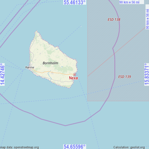
Nexø GPS coordinates[2]
55° 3' 38.412" North, 15° 7' 50.088" East
| Map corner | latitude | longitude |
|---|---|---|
| Upper-left | 55.46133°, | 14.42746° |
| Center: | 55.06067°, | 15.13058° |
| Lower-right: | 54.65596°, | 15.83371° |
| Map W x H: | 89.5×89.5 km | = 55.6×55.6mi |
| max Lat: | 57.72093° ⇑89.5% North |
| Nexø: | 55.06067° |
| min Lat: | ⇓10.5% South 54.57644° |
| min Long | Nexø | max Long |
| 8.12605° | 15.13058° | 15.18662° |
| W 99.7%⇐ | ⇒0.3% E |
Elevation
Elevation of Nexø is 4 m = 13 ft, and this is 23.3 m = 76 ft below average elevation for this country.
| Max E: |
114 m = 374 ft | 92.7% |
| Avg. | 27.3 m = 90 ft | |
| Nexø | 4 m = 13 ft | |
Min E: |
0 m = 0 ft | 7.3% |
See also: Denmark elevation on elevation.city.
Geographical zone
Nexø is located in North temperate zone (between Tropic of Cancer and the Arctic Circle). Distance of this North polar circle is 1279 km =794.7 mi to North.| Distance of | km | miles | from Nexø |
|---|---|---|---|
| North Pole | 3884.9 | 2414 | to North |
| Arctic Circle | 1279 | 794.7 | to North |
| Tropic Cancer | 3516.3 | 2184.9 | to South |
| Equator | 6122.2 | 3804.2 | to South |


Nearby cities:
15 places around Nexø: (largest is in red/bold)
• Charlottenlund
178.7 km =111 mi,  295°
295°
• Christianshavn
174.1 km =108.2 mi,  293°
293°
• Christiansø
29.1 km =18.1 mi,  7°
7°
• Copenhagen
175.9 km =109.3 mi, 292°
• Dragør
166.4 km =103.4 mi, 290°
• Frederiksberg
177.9 km =110.5 mi, 292°
• Hvidovre
180.5 km =112.2 mi, 291°
• Rødvig
176.1 km =109.4 mi,  277°
277°
• Rønne
27.4 km =17 mi, 279°
• Stege
181.6 km =112.8 mi,  267°
267°
• Store Heddinge
176.2 km =109.5 mi, 279°
• Tårnby
172 km =106.9 mi, 291°
• Vanløse
180.8 km =112.3 mi, 292°
• Vibekevang
177.8 km =110.5 mi, 293°
• Åkirkeby
13.5 km =8.4 mi, 274°
Sources, notices
• [Note1] Compared only with cities in Denmark existing in our database
• [Src1] Map data: © OpenStreetMap contributors (CC-BY-SA)
• [Src2] Other city data from geonames.org with taken over terms of usage.
• [Src3] Geographical zone / Annual Mean Temperature by Robert A. Rohde @ Wikipedia
