Åkirkeby geodata
Åkirkeby (Capital Region) is a populated place; located in Denmark in Europe/Copenhagen (GMT+2) time zone. With population of 2,195 people, there are 283 cities with bigger population in this country. Compared to other cities in Denmark, 88.9% of cities are located further ↑North; 99.4% of cities are located further ←West and 98.5% of cities have lower elevation than Åkirkeby. Note1


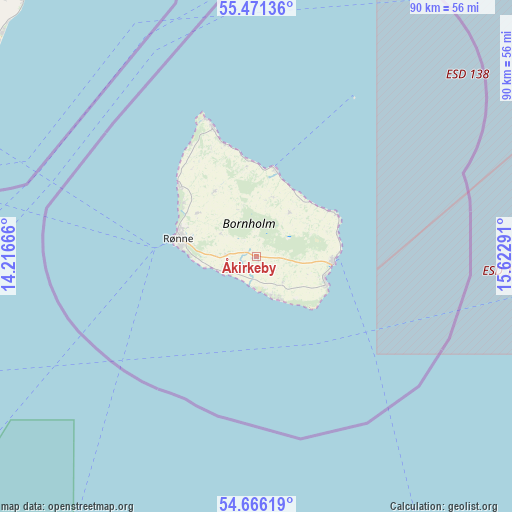
Åkirkeby GPS coordinates[2]
55° 4' 14.88" North, 14° 55' 11.208" East
| Map corner | latitude | longitude |
|---|---|---|
| Upper-left | 55.47136°, | 14.21666° |
| Center: | 55.0708°, | 14.91978° |
| Lower-right: | 54.66619°, | 15.62291° |
| Map W x H: | 89.5×89.5 km | = 55.6×55.6mi |
| max Lat: | 57.72093° ⇑88.9% North |
| Åkirkeby: | 55.0708° |
| min Lat: | ⇓11.1% South 54.57644° |
| min Long | Åkirkeby | max Long |
| 8.12605° | 14.91978° | 15.18662° |
| W 99.4%⇐ | ⇒0.59999999999999% E |
Elevation
Elevation of Åkirkeby is 88 m = 289 ft, and this is 60.7 m = 199 ft above average elevation for this country.
| Max E: |
114 m = 374 ft | 1.5% |
| Åkirkeby | 88 m 289 ft | |
| Avg. | 27.3 m = 90 ft | |
Min E: |
0 m = 0 ft | 98.5% |
See also: Denmark elevation on elevation.city.
Geographical zone
Åkirkeby is located in North temperate zone (between Tropic of Cancer and the Arctic Circle). Distance of this North polar circle is 1277.9 km =794.1 mi to North.| Distance of | km | miles | from Åkirkeby |
|---|---|---|---|
| North Pole | 3883.8 | 2413.3 | to North |
| Arctic Circle | 1277.9 | 794.1 | to North |
| Tropic Cancer | 3517.4 | 2185.6 | to South |
| Equator | 6123.3 | 3804.8 | to South |


Nearby cities:
15 places around Åkirkeby: (largest is in red/bold)
• Charlottenlund
166.3 km =103.3 mi,  297°
297°
• Christianshavn
161.4 km =100.3 mi,  294°
294°
• Christiansø
32.5 km =20.2 mi,  31°
31°
• Copenhagen
163.2 km =101.4 mi, 294°
• Dragør
153.5 km =95.4 mi, 292°
• Frederiksberg
165.2 km =102.7 mi, 294°
• Hvidovre
167.8 km =104.3 mi, 292°
• Nexø
13.5 km =8.4 mi,  94°
94°
• Rødvig
162.6 km =101 mi,  277°
277°
• Rønne
14 km =8.7 mi, 283°
• Stege
168.2 km =104.5 mi,  266°
266°
• Store Heddinge
162.8 km =101.2 mi, 279°
• Tårnby
159.3 km =99 mi, 292°
• Vanløse
168.1 km =104.5 mi, 293°
• Vibekevang
165.2 km =102.7 mi, 295°
Sources, notices
• [Note1] Compared only with cities in Denmark existing in our database
• [Src1] Map data: © OpenStreetMap contributors (CC-BY-SA)
• [Src2] Other city data from geonames.org with taken over terms of usage.
• [Src3] Geographical zone / Annual Mean Temperature by Robert A. Rohde @ Wikipedia
