Christiansfeld geodata
Christiansfeld (South Denmark) is a populated place; located in Denmark in Europe/Copenhagen (GMT+2) time zone. With population of 2,709 people, there are 234 cities with bigger population in this country. Compared to other cities in Denmark, 78.1% of cities are located further ↑North; 79.5% of cities are located further →East and 57.9% of cities have lower elevation than Christiansfeld. Note1


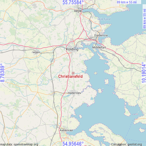
Christiansfeld GPS coordinates[2]
55° 21' 29.412" North, 9° 29' 13.236" East
| Map corner | latitude | longitude |
|---|---|---|
| Upper-left | 55.75584°, | 8.78389° |
| Center: | 55.35817°, | 9.48701° |
| Lower-right: | 54.95646°, | 10.19014° |
| Map W x H: | 88.9×88.9 km | = 55.2×55.2mi |
| max Lat: | 57.72093° ⇑78.1% North |
| Christiansfeld: | 55.35817° |
| min Lat: | ⇓21.9% South 54.57644° |
| min Long | Christiansfeld | max Long |
| 8.12605° | 9.48701° | 15.18662° |
| W 20.5%⇐ | ⇒79.5% E |
Elevation
Elevation of Christiansfeld is 28 m = 92 ft, and this is 0.7 m = 2 ft above average elevation for this country.
| Max E: |
114 m = 374 ft | 42.1% |
| Christiansfeld | 28 m 92 ft | |
| Avg. | 27.3 m = 90 ft | |
Min E: |
0 m = 0 ft | 57.9% |
See also: Denmark elevation on elevation.city.
Geographical zone
Christiansfeld is located in North temperate zone (between Tropic of Cancer and the Arctic Circle). Distance of this North polar circle is 1245.9 km =774.2 mi to North.| Distance of | km | miles | from Christiansfeld |
|---|---|---|---|
| North Pole | 3851.8 | 2393.4 | to North |
| Arctic Circle | 1245.9 | 774.2 | to North |
| Tropic Cancer | 3549.3 | 2205.4 | to South |
| Equator | 6155.3 | 3824.7 | to South |


Nearby cities:
15 places around Christiansfeld: (largest is in red/bold)
• Assens
27.9 km =17.3 mi,  110°
110°
• Haderslev
12.1 km =7.5 mi,  179°
179°
• Kolding
14.7 km =9.1 mi,  356°
356°
• Lunderskov
18.3 km =11.4 mi,  319°
319°
• Middelfart
22.5 km =14 mi,  43°
43°
• Nørre Åby
27.3 km =17 mi,  65°
65°
• Rødding
26.8 km =16.7 mi,  271°
271°
• Snoghøj
23.5 km =14.6 mi, 38°
• Starup
13.4 km =8.3 mi,  166°
166°
• Strib
26.9 km =16.7 mi, 41°
• Sønder Bjert
11.7 km =7.3 mi,  25°
25°
• Taulov
22.4 km =13.9 mi,  21°
21°
• Vamdrup
14.9 km =9.3 mi,  301°
301°
• Vejen
25.9 km =16.1 mi, 301°
• Vojens
16.9 km =10.5 mi,  222°
222°
Sources, notices
• [Note1] Compared only with cities in Denmark existing in our database
• [Src1] Map data: © OpenStreetMap contributors (CC-BY-SA)
• [Src2] Other city data from geonames.org with taken over terms of usage.
• [Src3] Geographical zone / Annual Mean Temperature by Robert A. Rohde @ Wikipedia
