Vamdrup geodata
Vamdrup (South Denmark) is a populated place; located in Denmark in Europe/Copenhagen (GMT+2) time zone. With population of 4,685 people, there are 137 cities with bigger population in this country. Compared to other cities in Denmark, 74.3% of cities are located further ↑North; 83.9% of cities are located further →East and 70.5% of cities have lower elevation than Vamdrup. Note1


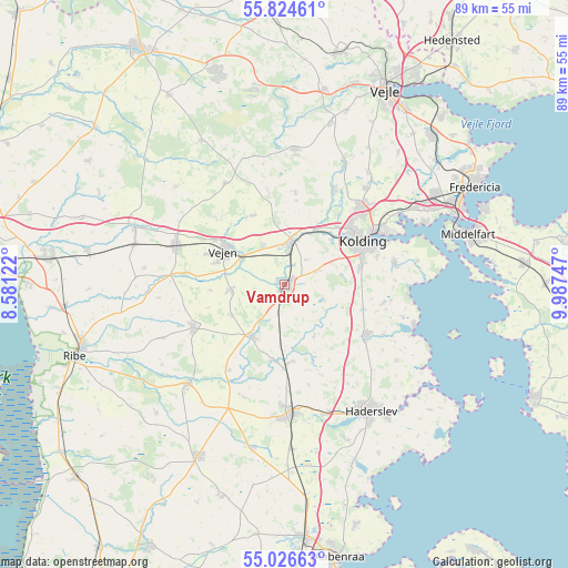
Vamdrup GPS coordinates[2]
55° 25' 39.504" North, 9° 17' 3.66" East
| Map corner | latitude | longitude |
|---|---|---|
| Upper-left | 55.82461°, | 8.58122° |
| Center: | 55.42764°, | 9.28435° |
| Lower-right: | 55.02663°, | 9.98747° |
| Map W x H: | 88.7×88.7 km | = 55.1×55.1mi |
| max Lat: | 57.72093° ⇑74.3% North |
| Vamdrup: | 55.42764° |
| min Lat: | ⇓25.7% South 54.57644° |
| min Long | Vamdrup | max Long |
| 8.12605° | 9.28435° | 15.18662° |
| W 16.1%⇐ | ⇒83.9% E |
Elevation
Elevation of Vamdrup is 37 m = 121 ft, and this is 9.7 m = 32 ft above average elevation for this country.
| Max E: |
114 m = 374 ft | 29.5% |
| Vamdrup | 37 m 121 ft | |
| Avg. | 27.3 m = 90 ft | |
Min E: |
0 m = 0 ft | 70.5% |
See also: Denmark elevation on elevation.city.
Geographical zone
Vamdrup is located in North temperate zone (between Tropic of Cancer and the Arctic Circle). Distance of this North polar circle is 1238.2 km =769.4 mi to North.| Distance of | km | miles | from Vamdrup |
|---|---|---|---|
| North Pole | 3844.1 | 2388.6 | to North |
| Arctic Circle | 1238.2 | 769.4 | to North |
| Tropic Cancer | 3557.1 | 2210.3 | to South |
| Equator | 6163 | 3829.5 | to South |


Nearby cities:
15 places around Vamdrup: (largest is in red/bold)
• Brørup
17.9 km =11.1 mi,  289°
289°
• Christiansfeld
14.9 km =9.3 mi,  121°
121°
• Egtved
21 km =13 mi,  3°
3°
• Gram
21.4 km =13.3 mi,  224°
224°
• Haderslev
23.6 km =14.7 mi,  147°
147°
• Holsted
24.8 km =15.4 mi, 291°
• Kolding
13.7 km =8.5 mi,  59°
59°
• Lunderskov
6.3 km =3.9 mi,  8°
8°
• Middelfart
29.4 km =18.3 mi,  72°
72°
• Rødding
15.6 km =9.7 mi,  243°
243°
• Starup
26.1 km =16.2 mi,  142°
142°
• Sønder Bjert
18.1 km =11.2 mi,  81°
81°
• Taulov
24.7 km =15.3 mi, 57°
• Vejen
11 km =6.8 mi,  302°
302°
• Vojens
20.2 km =12.6 mi,  176°
176°
Sources, notices
• [Note1] Compared only with cities in Denmark existing in our database
• [Src1] Map data: © OpenStreetMap contributors (CC-BY-SA)
• [Src2] Other city data from geonames.org with taken over terms of usage.
• [Src3] Geographical zone / Annual Mean Temperature by Robert A. Rohde @ Wikipedia
