Ejby geodata
Ejby (South Denmark) is a populated place; located in Denmark in Europe/Copenhagen (GMT+2) time zone. With population of 1,996 people, there are 304 cities with bigger population in this country. Compared to other cities in Denmark, 74% of cities are located further ↑North; 64.3% of cities are located further →East and 54.1% of cities have lower elevation than Ejby. Note1


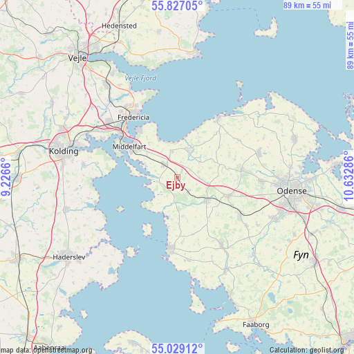
Ejby GPS coordinates[2]
55° 25' 48.36" North, 9° 55' 47.028" East
| Map corner | latitude | longitude |
|---|---|---|
| Upper-left | 55.82705°, | 9.2266° |
| Center: | 55.4301°, | 9.92973° |
| Lower-right: | 55.02912°, | 10.63286° |
| Map W x H: | 88.7×88.7 km | = 55.1×55.1mi |
| max Lat: | 57.72093° ⇑74% North |
| Ejby: | 55.4301° |
| min Lat: | ⇓26% South 54.57644° |
| min Long | Ejby | max Long |
| 8.12605° | 9.92973° | 15.18662° |
| W 35.7%⇐ | ⇒64.3% E |
Elevation
Elevation of Ejby is 25 m = 82 ft, and this is 2.3 m = 8 ft below average elevation for this country.
| Max E: |
114 m = 374 ft | 45.9% |
| Avg. | 27.3 m = 90 ft | |
| Ejby | 25 m = 82 ft | |
Min E: |
0 m = 0 ft | 54.1% |
See also: Denmark elevation on elevation.city.
Geographical zone
Ejby is located in North temperate zone (between Tropic of Cancer and the Arctic Circle). Distance of this North polar circle is 1237.9 km =769.2 mi to North.| Distance of | km | miles | from Ejby |
|---|---|---|---|
| North Pole | 3843.8 | 2388.4 | to North |
| Arctic Circle | 1237.9 | 769.2 | to North |
| Tropic Cancer | 3557.3 | 2210.4 | to South |
| Equator | 6163.2 | 3829.6 | to South |


Nearby cities:
15 places around Ejby: (largest is in red/bold)
• Assens
17.9 km =11.1 mi,  185°
185°
• Bogense
18.2 km =11.3 mi,  33°
33°
• Brenderup
6.8 km =4.2 mi, 27°
• Fredericia
18.8 km =11.7 mi,  323°
323°
• Glamsbjerg
20.7 km =12.9 mi,  147°
147°
• Harndrup
7.1 km =4.4 mi,  55°
55°
• Middelfart
15.1 km =9.4 mi,  303°
303°
• Nørre Åby
4.7 km =2.9 mi, 317°
• Snoghøj
16.7 km =10.4 mi,  308°
308°
• Strib
15.9 km =9.9 mi, 320°
• Søndersø
21.4 km =13.3 mi,  73°
73°
• Tommerup
21.4 km =13.3 mi,  125°
125°
• Tommerup Stationsby
18.2 km =11.3 mi,  121°
121°
• Vissenbjerg
14.1 km =8.8 mi,  110°
110°
• Årup
9.5 km =5.9 mi, 131°
Sources, notices
• [Note1] Compared only with cities in Denmark existing in our database
• [Src1] Map data: © OpenStreetMap contributors (CC-BY-SA)
• [Src2] Other city data from geonames.org with taken over terms of usage.
• [Src3] Geographical zone / Annual Mean Temperature by Robert A. Rohde @ Wikipedia
