Nørre Åby geodata
Nørre Åby (South Denmark) is a populated place; located in Denmark in Europe/Copenhagen (GMT+2) time zone. With population of 2,678 people, there are 239 cities with bigger population in this country. Compared to other cities in Denmark, 71.1% of cities are located further ↑North; 66.7% of cities are located further →East and 50.9% of cities have lower elevation than Nørre Åby. Note1


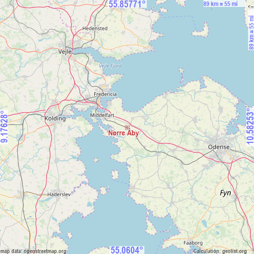
Nørre Åby GPS coordinates[2]
55° 27' 39.852" North, 9° 52' 45.84" East
| Map corner | latitude | longitude |
|---|---|---|
| Upper-left | 55.85771°, | 9.17628° |
| Center: | 55.46107°, | 9.8794° |
| Lower-right: | 55.0604°, | 10.58253° |
| Map W x H: | 88.7×88.6 km | = 55.1×55.1mi |
| max Lat: | 57.72093° ⇑71.1% North |
| Nørre Åby: | 55.46107° |
| min Lat: | ⇓28.9% South 54.57644° |
| min Long | Nørre Åby | max Long |
| 8.12605° | 9.8794° | 15.18662° |
| W 33.3%⇐ | ⇒66.7% E |
Elevation
Elevation of Nørre Åby is 23 m = 75 ft, and this is 4.3 m = 14 ft below average elevation for this country.
| Max E: |
114 m = 374 ft | 49.1% |
| Avg. | 27.3 m = 90 ft | |
| Nørre Åby | 23 m = 75 ft | |
Min E: |
0 m = 0 ft | 50.9% |
See also: Denmark elevation on elevation.city.
Geographical zone
Nørre Åby is located in North temperate zone (between Tropic of Cancer and the Arctic Circle). Distance of this North polar circle is 1234.5 km =767.1 mi to North.| Distance of | km | miles | from Nørre Åby |
|---|---|---|---|
| North Pole | 3840.4 | 2386.3 | to North |
| Arctic Circle | 1234.5 | 767.1 | to North |
| Tropic Cancer | 3560.8 | 2212.6 | to South |
| Equator | 6166.7 | 3831.8 | to South |


Nearby cities:
15 places around Nørre Åby: (largest is in red/bold)
• Assens
21.3 km =13.2 mi,  176°
176°
• Bogense
17.7 km =11 mi,  48°
48°
• Brenderup
6.8 km =4.2 mi,  67°
67°
• Ejby
4.7 km =2.9 mi,  137°
137°
• Fredericia
14.1 km =8.8 mi,  325°
325°
• Harndrup
9 km =5.6 mi,  86°
86°
• Middelfart
10.6 km =6.6 mi,  297°
297°
• Snoghøj
12.1 km =7.5 mi, 304°
• Strib
11.3 km =7 mi,  321°
321°
• Sønder Bjert
19.7 km =12.2 mi,  267°
267°
• Søndersø
23.8 km =14.8 mi,  83°
83°
• Taulov
19.1 km =11.9 mi, 299°
• Tommerup Stationsby
22.7 km =14.1 mi,  124°
124°
• Vissenbjerg
18.4 km =11.4 mi, 117°
• Årup
14.1 km =8.8 mi,  133°
133°
Sources, notices
• [Note1] Compared only with cities in Denmark existing in our database
• [Src1] Map data: © OpenStreetMap contributors (CC-BY-SA)
• [Src2] Other city data from geonames.org with taken over terms of usage.
• [Src3] Geographical zone / Annual Mean Temperature by Robert A. Rohde @ Wikipedia
