Sebdou geodata
Sebdou (Tlemcen) is a populated place; located in Algeria in Africa/Algiers (GMT+1) time zone. With population of 41,146 people, there are 123 cities with bigger population in this country. Compared to other cities in Algeria, 85.7% of cities are located further ↑North; 96.9% of cities are located further →East and 84.5% of cities have lower elevation than Sebdou. Note1


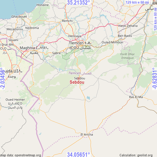
Sebdou GPS coordinates[2]
34° 38' 13.308" North, 1° 19' 53.148" West
| Map corner | latitude | longitude |
|---|---|---|
| Upper-left | 35.21352°, | -2.03456° |
| Center: | 34.63703°, | -1.33143° |
| Lower-right: | 34.05651°, | -0.62831° |
| Map W x H: | 128.6×128.6 km | = 79.9×79.9mi |
| max Lat: | 36.92917° ⇑85.7% North |
| Sebdou: | 34.63703° |
| min Lat: | ⇓14.3% South 22.785° |
| min Long | Sebdou | max Long |
| -8.14743° | -1.33143° | 8.46667° |
| W 3.1%⇐ | ⇒96.9% E |
Elevation
Elevation of Sebdou is 920 m = 3018 ft, and this is 481.5 m = 1580 ft above average elevation for this country.
| Max E: |
1392 m = 4567 ft | 15.5% |
| Sebdou | 920 m 3018 ft | |
| Avg. | 438.5 m = 1439 ft | |
Min E: |
5 m = 16 ft | 84.5% |
See also: Sebdou elevation on elevation.city.
Geographical zone
Sebdou is located in North temperate zone (between Tropic of Cancer and the Arctic Circle). Distance of this Northern Tropic circle is 1245.4 km =773.9 mi to South.| Distance of | km | miles | from Sebdou |
|---|---|---|---|
| North Pole | 6155.8 | 3825 | to North |
| Arctic Circle | 3549.9 | 2205.8 | to North |
| Tropic Cancer | 1245.4 | 773.9 | to South |
| Equator | 3851.3 | 2393.1 | to South |


Nearby cities:
15 places around Sebdou: (largest is in red/bold)
• Aïn Temouchent
75.5 km =46.9 mi,  13°
13°
• Beni Mester
27.3 km =17 mi,  342°
342°
• Beni Saf
74 km =46 mi,  356°
356°
• Bensekrane
49.6 km =30.8 mi, 11°
• Chetouane
31.8 km =19.8 mi, 5°
• El Malah
86.7 km =53.9 mi, 14°
• Hennaya
35.1 km =21.8 mi,  354°
354°
• Mansoûra
25 km =15.5 mi, 358°
• Nedroma
56.6 km =35.2 mi,  317°
317°
• Ouled Mimoun
40.3 km =25 mi,  42°
42°
• Remchi
48.2 km =30 mi, 348°
• Sidi Abdelli
51.2 km =31.8 mi,  20°
20°
• Sidi Bel Abbès
88.7 km =55.1 mi,  46°
46°
• Sidi Senoussi سيدي سنوسي
45.5 km =28.3 mi,  28°
28°
• Tlemcen
26.9 km =16.7 mi,  3°
3°
Sources, notices
• [Note1] Compared only with cities in Algeria existing in our database
• [Src1] Map data: © OpenStreetMap contributors (CC-BY-SA)
• [Src2] Other city data from geonames.org with taken over terms of usage.
• [Src3] Geographical zone / Annual Mean Temperature by Robert A. Rohde @ Wikipedia
