Tamanrasset geodata
Tamanrasset is a seat of a first-order administrative division; located in Algeria in Africa/Algiers (GMT+1) time zone. With population of 73,128 people, there are 53 cities with bigger population in this country. Compared to other cities in Algeria, 100% of cities are located further ↑North; 75.2% of cities are located further ←West and 99.6% of cities have lower elevation than Tamanrasset. Note1


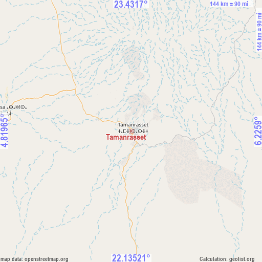
Tamanrasset GPS coordinates[2]
22° 47' 6" North, 5° 31' 22.008" East
| Map corner | latitude | longitude |
|---|---|---|
| Upper-left | 23.4317°, | 4.81965° |
| Center: | 22.785°, | 5.52278° |
| Lower-right: | 22.13521°, | 6.2259° |
| Map W x H: | 144.2×144.2 km | = 89.6×89.6mi |
| max Lat: | 36.92917° ⇑100% North |
| Tamanrasset: | 22.785° |
| min Lat: | ⇓0% South 22.785° |
| min Long | Tamanrasset | max Long |
| -8.14743° | 5.52278° | 8.46667° |
| W 75.2%⇐ | ⇒24.8% E |
Elevation
Elevation of Tamanrasset is 1372 m = 4501 ft, and this is 933.5 m = 3063 ft above average elevation for this country.
| Max E: |
1392 m = 4567 ft | 0.40000000000001% |
| Tamanrasset | 1372 m 4501 ft | |
| Avg. | 438.5 m = 1439 ft | |
Min E: |
5 m = 16 ft | 99.6% |
See also: Tamanrasset elevation on elevation.city.
Geographical zone
Tamanrasset is located in North Torrid zone (between Equator and Tropic of Cancer). Distance of this Northern Tropic circle is 72.5 km =45 mi to North.| Distance of | km | miles | from Tamanrasset |
|---|---|---|---|
| North Pole | 7473.6 | 4643.9 | to North |
| Arctic Circle | 4867.7 | 3024.6 | to North |
| Tropic Cancer | 72.5 | 45 | to North |
| Equator | 2533.5 | 1574.2 | to South |


Nearby cities:
15 places around Tamanrasset: (largest is in red/bold)
• Adrar
813.3 km =505.4 mi,  314°
314°
• Aoulef
645.4 km =401 mi,  316°
316°
• Berriane
1129.7 km =702 mi,  351°
351°
• El Hadjira
1092.8 km =679 mi,  359°
359°
• Ghardaïa
1094.4 km =680 mi, 350°
• Hassi Messaoud
990.6 km =615.5 mi,  3°
3°
• I-n-Salah
579.2 km =359.9 mi,  327°
327°
• Illizi
507.5 km =315.3 mi,  35°
35°
• Metlili Chaamba
1070.5 km =665.2 mi, 349°
• Ouargla
1019.2 km =633.3 mi, 358°
• Reggane
694.8 km =431.7 mi, 308°
• Rouissat
1016.3 km =631.5 mi, 359°
• Tebesbest
1150.1 km =714.6 mi, 2°
• Timimoun
893.3 km =555.1 mi, 323°
• Touggourt
1148.7 km =713.8 mi, 2°
Sources, notices
• [Note1] Compared only with cities in Algeria existing in our database
• [Src1] Map data: © OpenStreetMap contributors (CC-BY-SA)
• [Src2] Other city data from geonames.org with taken over terms of usage.
• [Src3] Geographical zone / Annual Mean Temperature by Robert A. Rohde @ Wikipedia
