Tebesbest geodata
Tebesbest (Ouargla) is a populated place; located in Algeria in Africa/Algiers (GMT+1) time zone. With population of 41,091 people, there are 124 cities with bigger population in this country. Compared to other cities in Algeria, 92.2% of cities are located further ↑North; 81.4% of cities are located further ←West and 82.6% of cities have higher elevation than Tebesbest. Note1


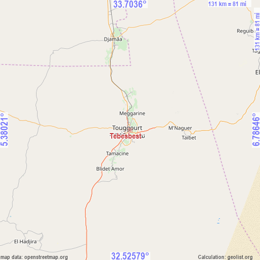
Tebesbest GPS coordinates[2]
33° 7' 0.012" North, 6° 4' 59.988" East
| Map corner | latitude | longitude |
|---|---|---|
| Upper-left | 33.7036°, | 5.38021° |
| Center: | 33.11667°, | 6.08333° |
| Lower-right: | 32.52579°, | 6.78646° |
| Map W x H: | 131×131 km | = 81.4×81.4mi |
| max Lat: | 36.92917° ⇑92.2% North |
| Tebesbest: | 33.11667° |
| min Lat: | ⇓7.8% South 22.785° |
| min Long | Tebesbest | max Long |
| -8.14743° | 6.08333° | 8.46667° |
| W 81.4%⇐ | ⇒18.6% E |
Elevation
Elevation of Tebesbest is 70 m = 230 ft, and this is 368.5 m = 1209 ft below average elevation for this country.
| Max E: |
1392 m = 4567 ft | 82.6% |
| Avg. | 438.5 m = 1439 ft | |
| Tebesbest | 70 m = 230 ft | |
Min E: |
5 m = 16 ft | 17.4% |
See also: Tebesbest elevation on elevation.city.
Geographical zone
Tebesbest is located in North temperate zone (between Tropic of Cancer and the Arctic Circle). Distance of this Northern Tropic circle is 1076.3 km =668.8 mi to South.| Distance of | km | miles | from Tebesbest |
|---|---|---|---|
| North Pole | 6324.8 | 3930 | to North |
| Arctic Circle | 3718.9 | 2310.8 | to North |
| Tropic Cancer | 1076.3 | 668.8 | to South |
| Equator | 3682.2 | 2288 | to South |


Nearby cities:
15 places around Tebesbest: (largest is in red/bold)
• Debila
92 km =57.2 mi,  61°
61°
• Djamaa
47.1 km =29.3 mi,  349°
349°
• El Hadjira
77.3 km =48 mi,  223°
223°
• El Oued
77.3 km =48 mi,  69°
69°
• Hassi Messaoud
159.7 km =99.2 mi,  180°
180°
• Megarine
8.4 km =5.2 mi,  2°
2°
• Ouargla
148 km =92 mi,  208°
208°
• Oumache
179.2 km =111.3 mi, 348°
• Reguiba
76.1 km =47.3 mi,  49°
49°
• Robbah
79 km =49.1 mi,  76°
76°
• Rouissat
149.3 km =92.8 mi, 207°
• Sidi Amrane
43.1 km =26.8 mi, 350°
• Sidi Khaled
173.8 km =108 mi,  324°
324°
• Touggourt
2.7 km =1.7 mi,  241°
241°
• Zeribet el Oued
178.6 km =111 mi,  12°
12°
Sources, notices
• [Note1] Compared only with cities in Algeria existing in our database
• [Src1] Map data: © OpenStreetMap contributors (CC-BY-SA)
• [Src2] Other city data from geonames.org with taken over terms of usage.
• [Src3] Geographical zone / Annual Mean Temperature by Robert A. Rohde @ Wikipedia
