Ghardaïa geodata
Ghardaïa (Ghardaia) is a seat of a first-order administrative division; located in Algeria in Africa/Algiers (GMT+1) time zone. With population of 93,423 people, there are 44 cities with bigger population in this country. Compared to other cities in Algeria, 95% of cities are located further ↑North; 52.3% of cities are located further ←West and 60.5% of cities have lower elevation than Ghardaïa. Note1


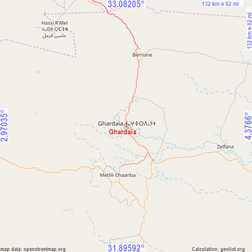
Ghardaïa GPS coordinates[2]
32° 29' 27.384" North, 3° 40' 24.492" East
| Map corner | latitude | longitude |
|---|---|---|
| Upper-left | 33.08205°, | 2.97035° |
| Center: | 32.49094°, | 3.67347° |
| Lower-right: | 31.89592°, | 4.3766° |
| Map W x H: | 131.9×131.9 km | = 82×82mi |
| max Lat: | 36.92917° ⇑95% North |
| Ghardaïa: | 32.49094° |
| min Lat: | ⇓5% South 22.785° |
| min Long | Ghardaïa | max Long |
| -8.14743° | 3.67347° | 8.46667° |
| W 52.3%⇐ | ⇒47.7% E |
Elevation
Elevation of Ghardaïa is 503 m = 1650 ft, and this is 64.5 m = 212 ft above average elevation for this country.
| Max E: |
1392 m = 4567 ft | 39.5% |
| Ghardaïa | 503 m 1650 ft | |
| Avg. | 438.5 m = 1439 ft | |
Min E: |
5 m = 16 ft | 60.5% |
See also: Ghardaïa elevation on elevation.city.
Geographical zone
Ghardaïa is located in North temperate zone (between Tropic of Cancer and the Arctic Circle). Distance of this Northern Tropic circle is 1006.7 km =625.5 mi to South.| Distance of | km | miles | from Ghardaïa |
|---|---|---|---|
| North Pole | 6394.4 | 3973.3 | to North |
| Arctic Circle | 3788.5 | 2354.1 | to North |
| Tropic Cancer | 1006.7 | 625.5 | to South |
| Equator | 3612.7 | 2244.8 | to South |


Nearby cities:
15 places around Ghardaïa: (largest is in red/bold)
• Aflou
232 km =144.2 mi,  321°
321°
• Berriane
38.3 km =23.8 mi,  13°
13°
• Brezina
235.4 km =146.3 mi,  286°
286°
• El Hadjira
172.9 km =107.4 mi,  85°
85°
• El Idrissia
241.9 km =150.3 mi,  333°
333°
• Hassi Messaoud
243.3 km =151.2 mi,  111°
111°
• Laghouat
163.9 km =101.8 mi, 332°
• Megarine
238.5 km =148.2 mi,  70°
70°
• Messaad
185.6 km =115.3 mi,  355°
355°
• Metlili Chaamba
25.2 km =15.7 mi,  188°
188°
• Ouargla
166.6 km =103.5 mi, 111°
• Rouissat
169.9 km =105.6 mi, 111°
• Tebesbest
235.7 km =146.5 mi, 72°
• Touggourt
233.1 km =144.8 mi, 72°
• ’Aïn el Bell
210.2 km =130.6 mi,  348°
348°
Sources, notices
• [Note1] Compared only with cities in Algeria existing in our database
• [Src1] Map data: © OpenStreetMap contributors (CC-BY-SA)
• [Src2] Other city data from geonames.org with taken over terms of usage.
• [Src3] Geographical zone / Annual Mean Temperature by Robert A. Rohde @ Wikipedia
