Berriane geodata
Berriane (Ghardaia) is a populated place; located in Algeria in Africa/Algiers (GMT+1) time zone. With population of 44,580 people, there are 112 cities with bigger population in this country. Compared to other cities in Algeria, 93.8% of cities are located further ↑North; 53.5% of cities are located further ←West and 62% of cities have lower elevation than Berriane. Note1


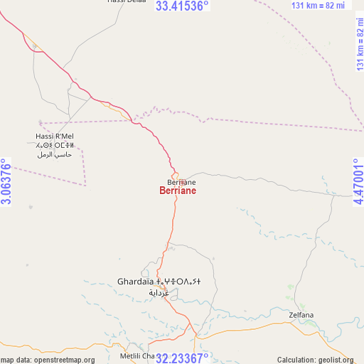
Berriane GPS coordinates[2]
32° 49' 35.328" North, 3° 46' 0.804" East
| Map corner | latitude | longitude |
|---|---|---|
| Upper-left | 33.41536°, | 3.06376° |
| Center: | 32.82648°, | 3.76689° |
| Lower-right: | 32.23367°, | 4.47001° |
| Map W x H: | 131.4×131.4 km | = 81.6×81.6mi |
| max Lat: | 36.92917° ⇑93.8% North |
| Berriane: | 32.82648° |
| min Lat: | ⇓6.2% South 22.785° |
| min Long | Berriane | max Long |
| -8.14743° | 3.76689° | 8.46667° |
| W 53.5%⇐ | ⇒46.5% E |
Elevation
Elevation of Berriane is 536 m = 1759 ft, and this is 97.5 m = 320 ft above average elevation for this country.
| Max E: |
1392 m = 4567 ft | 38% |
| Berriane | 536 m 1759 ft | |
| Avg. | 438.5 m = 1439 ft | |
Min E: |
5 m = 16 ft | 62% |
See also: Berriane elevation on elevation.city.
Geographical zone
Berriane is located in North temperate zone (between Tropic of Cancer and the Arctic Circle). Distance of this Northern Tropic circle is 1044 km =648.7 mi to South.| Distance of | km | miles | from Berriane |
|---|---|---|---|
| North Pole | 6357.1 | 3950.1 | to North |
| Arctic Circle | 3751.2 | 2330.9 | to North |
| Tropic Cancer | 1044 | 648.7 | to South |
| Equator | 3650 | 2268 | to South |


Nearby cities:
15 places around Berriane: (largest is in red/bold)
• Aflou
210.5 km =130.8 mi,  312°
312°
• Charef
218.8 km =136 mi,  335°
335°
• Djelfa
210.5 km =130.8 mi,  347°
347°
• El Hadjira
165 km =102.5 mi,  98°
98°
• El Idrissia
213.5 km =132.7 mi,  327°
327°
• Ghardaïa
38.3 km =23.8 mi,  193°
193°
• Laghouat
136.9 km =85.1 mi,  322°
322°
• Messaad
149.7 km =93 mi, 350°
• Metlili Chaamba
63.5 km =39.5 mi, 191°
• Ouargla
175.8 km =109.2 mi,  123°
123°
• Rouissat
179.4 km =111.5 mi, 124°
• Sidi Khaled
207.1 km =128.7 mi,  33°
33°
• Tebesbest
218.5 km =135.8 mi,  81°
81°
• Touggourt
216 km =134.2 mi, 81°
• ’Aïn el Bell
176 km =109.4 mi, 343°
Sources, notices
• [Note1] Compared only with cities in Algeria existing in our database
• [Src1] Map data: © OpenStreetMap contributors (CC-BY-SA)
• [Src2] Other city data from geonames.org with taken over terms of usage.
• [Src3] Geographical zone / Annual Mean Temperature by Robert A. Rohde @ Wikipedia
