Metlili Chaamba geodata
Metlili Chaamba (Ghardaia) is a populated place; located in Algeria in Africa/Algiers (GMT+1) time zone. With population of 50,117 people, there are 100 cities with bigger population in this country. Compared to other cities in Algeria, 95.3% of cities are located further ↑North; 51.6% of cities are located further ←West and 62.8% of cities have lower elevation than Metlili Chaamba. Note1


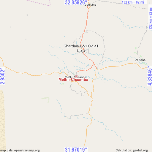
Metlili Chaamba GPS coordinates[2]
32° 16' 0.012" North, 3° 37' 59.988" East
| Map corner | latitude | longitude |
|---|---|---|
| Upper-left | 32.85926°, | 2.9302° |
| Center: | 32.26667°, | 3.63333° |
| Lower-right: | 31.67019°, | 4.33645° |
| Map W x H: | 132.2×132.2 km | = 82.1×82.1mi |
| max Lat: | 36.92917° ⇑95.3% North |
| Metlili Chaamba: | 32.26667° |
| min Lat: | ⇓4.7% South 22.785° |
| min Long | Metlili Chaamba | max Long |
| -8.14743° | 3.63333° | 8.46667° |
| W 51.6%⇐ | ⇒48.4% E |
Elevation
Elevation of Metlili Chaamba is 542 m = 1778 ft, and this is 103.5 m = 340 ft above average elevation for this country.
| Max E: |
1392 m = 4567 ft | 37.2% |
| Metlili Chaamba | 542 m 1778 ft | |
| Avg. | 438.5 m = 1439 ft | |
Min E: |
5 m = 16 ft | 62.8% |
See also: Metlili Chaamba elevation on elevation.city.
Geographical zone
Metlili Chaamba is located in North temperate zone (between Tropic of Cancer and the Arctic Circle). Distance of this Northern Tropic circle is 981.8 km =610.1 mi to South.| Distance of | km | miles | from Metlili Chaamba |
|---|---|---|---|
| North Pole | 6419.3 | 3988.8 | to North |
| Arctic Circle | 3813.5 | 2369.6 | to North |
| Tropic Cancer | 981.8 | 610.1 | to South |
| Equator | 3587.7 | 2229.3 | to South |


Nearby cities:
15 places around Metlili Chaamba: (largest is in red/bold)
• Aflou
249.9 km =155.3 mi,  325°
325°
• Berriane
63.5 km =39.5 mi,  11°
11°
• Brezina
240.5 km =149.4 mi,  292°
292°
• El Hadjira
180.5 km =112.2 mi,  77°
77°
• Ghardaïa
25.2 km =15.7 mi, 8°
• Hassi Messaoud
239.1 km =148.6 mi,  105°
105°
• Laghouat
184.9 km =114.9 mi,  337°
337°
• Megarine
251.5 km =156.3 mi,  65°
65°
• Messaad
210.2 km =130.6 mi,  356°
356°
• Ouargla
163.2 km =101.4 mi,  102°
102°
• Rouissat
166.1 km =103.2 mi, 103°
• Sidi Amrane
260.6 km =161.9 mi,  58°
58°
• Tebesbest
248 km =154.1 mi, 67°
• Touggourt
245.3 km =152.4 mi, 67°
• ’Aïn el Bell
234.1 km =145.5 mi,  350°
350°
Sources, notices
• [Note1] Compared only with cities in Algeria existing in our database
• [Src1] Map data: © OpenStreetMap contributors (CC-BY-SA)
• [Src2] Other city data from geonames.org with taken over terms of usage.
• [Src3] Geographical zone / Annual Mean Temperature by Robert A. Rohde @ Wikipedia
