Ouargla geodata
Ouargla is a seat of a first-order administrative division; located in Algeria in Africa/Algiers (GMT+1) time zone. With population of 129,402 people, there are 30 cities with bigger population in this country. Compared to other cities in Algeria, 95.7% of cities are located further ↑North; 72.9% of cities are located further ←West and 66.7% of cities have higher elevation than Ouargla. Note1


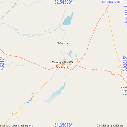
Ouargla GPS coordinates[2]
31° 56' 57.552" North, 5° 19' 30.072" East
| Map corner | latitude | longitude |
|---|---|---|
| Upper-left | 32.54399°, | 4.6219° |
| Center: | 31.94932°, | 5.32502° |
| Lower-right: | 31.35078°, | 6.02815° |
| Map W x H: | 132.7×132.7 km | = 82.5×82.5mi |
| max Lat: | 36.92917° ⇑95.7% North |
| Ouargla: | 31.94932° |
| min Lat: | ⇓4.3% South 22.785° |
| min Long | Ouargla | max Long |
| -8.14743° | 5.32502° | 8.46667° |
| W 72.9%⇐ | ⇒27.1% E |
Elevation
Elevation of Ouargla is 138 m = 453 ft, and this is 300.5 m = 986 ft below average elevation for this country.
| Max E: |
1392 m = 4567 ft | 66.7% |
| Avg. | 438.5 m = 1439 ft | |
| Ouargla | 138 m = 453 ft | |
Min E: |
5 m = 16 ft | 33.3% |
See also: Ouargla elevation on elevation.city.
Geographical zone
Ouargla is located in North temperate zone (between Tropic of Cancer and the Arctic Circle). Distance of this Northern Tropic circle is 946.5 km =588.1 mi to South.| Distance of | km | miles | from Ouargla |
|---|---|---|---|
| North Pole | 6454.6 | 4010.7 | to North |
| Arctic Circle | 3848.7 | 2391.5 | to North |
| Tropic Cancer | 946.5 | 588.1 | to South |
| Equator | 3552.4 | 2207.4 | to South |


Nearby cities:
15 places around Ouargla: (largest is in red/bold)
• Berriane
175.8 km =109.2 mi,  303°
303°
• Debila
231.2 km =143.7 mi,  41°
41°
• Djamaa
186.9 km =116.1 mi,  19°
19°
• El Hadjira
75.9 km =47.2 mi,  13°
13°
• El Oued
212.6 km =132.1 mi, 42°
• Ghardaïa
166.6 km =103.5 mi,  291°
291°
• Hassi Messaoud
76.7 km =47.7 mi,  112°
112°
• Megarine
155.5 km =96.6 mi,  27°
27°
• Metlili Chaamba
163.2 km =101.4 mi,  282°
282°
• Reguiba
221 km =137.3 mi, 35°
• Robbah
209.5 km =130.2 mi,  45°
45°
• Rouissat
3.7 km =2.3 mi,  139°
139°
• Sidi Amrane
183.8 km =114.2 mi, 20°
• Tebesbest
148 km =92 mi, 28°
• Touggourt
145.7 km =90.5 mi, 28°
Sources, notices
• [Note1] Compared only with cities in Algeria existing in our database
• [Src1] Map data: © OpenStreetMap contributors (CC-BY-SA)
• [Src2] Other city data from geonames.org with taken over terms of usage.
• [Src3] Geographical zone / Annual Mean Temperature by Robert A. Rohde @ Wikipedia
