Sougueur geodata
Sougueur (Tiaret) is a populated place; located in Algeria in Africa/Algiers (GMT+1) time zone. With population of 68,654 people, there are 62 cities with bigger population in this country. Compared to other cities in Algeria, 75.6% of cities are located further ↑North; 75.2% of cities are located further →East and 96.9% of cities have lower elevation than Sougueur. Note1


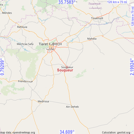
Sougueur GPS coordinates[2]
35° 11' 8.448" North, 1° 29' 46.032" East
| Map corner | latitude | longitude |
|---|---|---|
| Upper-left | 35.7583°, | 0.79299° |
| Center: | 35.18568°, | 1.49612° |
| Lower-right: | 34.609°, | 2.19924° |
| Map W x H: | 127.8×127.8 km | = 79.4×79.4mi |
| max Lat: | 36.92917° ⇑75.6% North |
| Sougueur: | 35.18568° |
| min Lat: | ⇓24.4% South 22.785° |
| min Long | Sougueur | max Long |
| -8.14743° | 1.49612° | 8.46667° |
| W 24.8%⇐ | ⇒75.2% E |
Elevation
Elevation of Sougueur is 1133 m = 3717 ft, and this is 694.5 m = 2279 ft above average elevation for this country.
| Max E: |
1392 m = 4567 ft | 3.1% |
| Sougueur | 1133 m 3717 ft | |
| Avg. | 438.5 m = 1439 ft | |
Min E: |
5 m = 16 ft | 96.9% |
See also: Sougueur elevation on elevation.city.
Geographical zone
Sougueur is located in North temperate zone (between Tropic of Cancer and the Arctic Circle). Distance of this Northern Tropic circle is 1306.4 km =811.8 mi to South.| Distance of | km | miles | from Sougueur |
|---|---|---|---|
| North Pole | 6094.8 | 3787.1 | to North |
| Arctic Circle | 3488.9 | 2167.9 | to North |
| Tropic Cancer | 1306.4 | 811.8 | to South |
| Equator | 3912.3 | 2431 | to South |


Nearby cities:
15 places around Sougueur: (largest is in red/bold)
• Ammi Moussa
83.5 km =51.9 mi,  335°
335°
• Commune des Béni Bou Attab
90.7 km =56.4 mi,  6°
6°
• Djebilet Rosfa
70 km =43.5 mi,  239°
239°
• Frenda
42.8 km =26.6 mi,  251°
251°
• Ksar Chellala
74.8 km =46.5 mi,  87°
87°
• Lardjem
62.8 km =39 mi,  4°
4°
• Mehdia daira de meghila
36.1 km =22.4 mi,  41°
41°
• Oued el Abtal
79.3 km =49.3 mi,  292°
292°
• Rouachdia
90.5 km =56.2 mi,  309°
309°
• Smala
89.4 km =55.6 mi, 311°
• Theniet el Had
90.1 km =56 mi,  32°
32°
• Tiaret
26.3 km =16.3 mi,  321°
321°
• Tissemsilt
54.9 km =34.1 mi, 31°
• Zemoura
89.8 km =55.8 mi, 311°
• ’Aïn Deheb
38.5 km =23.9 mi,  173°
173°
Sources, notices
• [Note1] Compared only with cities in Algeria existing in our database
• [Src1] Map data: © OpenStreetMap contributors (CC-BY-SA)
• [Src2] Other city data from geonames.org with taken over terms of usage.
• [Src3] Geographical zone / Annual Mean Temperature by Robert A. Rohde @ Wikipedia
