Tiaret geodata
Tiaret is a seat of a first-order administrative division; located in Algeria in Africa/Algiers (GMT+1) time zone. With population of 178,915 people, there are 12 cities with bigger population in this country. Compared to other cities in Algeria, 71.7% of cities are located further ↑North; 76% of cities are located further →East and 91.1% of cities have lower elevation than Tiaret. Note1


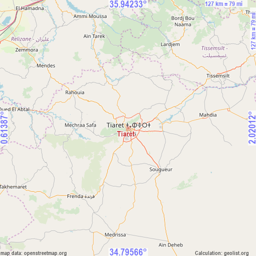
Tiaret GPS coordinates[2]
35° 22' 15.708" North, 1° 19' 1.164" East
| Map corner | latitude | longitude |
|---|---|---|
| Upper-left | 35.94233°, | 0.61387° |
| Center: | 35.37103°, | 1.31699° |
| Lower-right: | 34.79566°, | 2.02012° |
| Map W x H: | 127.5×127.5 km | = 79.2×79.2mi |
| max Lat: | 36.92917° ⇑71.7% North |
| Tiaret: | 35.37103° |
| min Lat: | ⇓28.3% South 22.785° |
| min Long | Tiaret | max Long |
| -8.14743° | 1.31699° | 8.46667° |
| W 24%⇐ | ⇒76% E |
Elevation
Elevation of Tiaret is 1031 m = 3383 ft, and this is 592.5 m = 1944 ft above average elevation for this country.
| Max E: |
1392 m = 4567 ft | 8.9% |
| Tiaret | 1031 m 3383 ft | |
| Avg. | 438.5 m = 1439 ft | |
Min E: |
5 m = 16 ft | 91.1% |
See also: Tiaret elevation on elevation.city.
Geographical zone
Tiaret is located in North temperate zone (between Tropic of Cancer and the Arctic Circle). Distance of this Northern Tropic circle is 1327 km =824.6 mi to South.| Distance of | km | miles | from Tiaret |
|---|---|---|---|
| North Pole | 6074.2 | 3774.3 | to North |
| Arctic Circle | 3468.3 | 2155.1 | to North |
| Tropic Cancer | 1327 | 824.6 | to South |
| Equator | 3932.9 | 2443.8 | to South |


Nearby cities:
15 places around Tiaret: (largest is in red/bold)
• Ammi Moussa
58.3 km =36.2 mi,  341°
341°
• Commune des Béni Bou Attab
74.5 km =46.3 mi,  21°
21°
• Djebilet Rosfa
71.4 km =44.4 mi,  217°
217°
• Djidiouia
76.2 km =47.3 mi,  324°
324°
• Frenda
41.8 km =26 mi, 215°
• Lardjem
46.9 km =29.1 mi,  26°
26°
• Mehdia daira de meghila
40.4 km =25.1 mi,  80°
80°
• Oued Rhiou
74.8 km =46.5 mi,  331°
331°
• Oued el Abtal
57.8 km =35.9 mi,  279°
279°
• Rouachdia
65 km =40.4 mi,  305°
305°
• Smala
63.8 km =39.6 mi, 307°
• Sougueur
26.3 km =16.3 mi,  141°
141°
• Tissemsilt
51.8 km =32.2 mi,  59°
59°
• Zemoura
64.1 km =39.8 mi, 307°
• ’Aïn Deheb
62.4 km =38.8 mi,  160°
160°
Sources, notices
• [Note1] Compared only with cities in Algeria existing in our database
• [Src1] Map data: © OpenStreetMap contributors (CC-BY-SA)
• [Src2] Other city data from geonames.org with taken over terms of usage.
• [Src3] Geographical zone / Annual Mean Temperature by Robert A. Rohde @ Wikipedia
