Skikda geodata
Skikda is a seat of a first-order administrative division; located in Algeria in Africa/Algiers (GMT+1) time zone. With population of 162,702 people, there are 17 cities with bigger population in this country. Compared to other cities in Algeria, 98.4% of cities are located further ↓South; 89.5% of cities are located further ←West and 94.2% of cities have higher elevation than Skikda. Note1


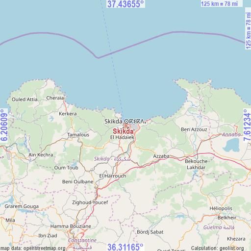
Skikda GPS coordinates[2]
36° 52' 34.212" North, 6° 54' 33.156" East
| Map corner | latitude | longitude |
|---|---|---|
| Upper-left | 37.43655°, | 6.20609° |
| Center: | 36.87617°, | 6.90921° |
| Lower-right: | 36.31165°, | 7.61234° |
| Map W x H: | 125.1×125.1 km | = 77.7×77.7mi |
| max Lat: | 36.92917° ⇑1.6% North |
| Skikda: | 36.87617° |
| min Lat: | ⇓98.4% South 22.785° |
| min Long | Skikda | max Long |
| -8.14743° | 6.90921° | 8.46667° |
| W 89.5%⇐ | ⇒10.5% E |
Elevation
Elevation of Skikda is 24 m = 79 ft, and this is 414.5 m = 1360 ft below average elevation for this country.
| Max E: |
1392 m = 4567 ft | 94.2% |
| Avg. | 438.5 m = 1439 ft | |
| Skikda | 24 m = 79 ft | |
Min E: |
5 m = 16 ft | 5.8% |
See also: Skikda elevation on elevation.city.
Geographical zone
Skikda is located in North temperate zone (between Tropic of Cancer and the Arctic Circle). Distance of this Northern Tropic circle is 1494.3 km =928.5 mi to South.| Distance of | km | miles | from Skikda |
|---|---|---|---|
| North Pole | 5906.8 | 3670.3 | to North |
| Arctic Circle | 3300.9 | 2051.1 | to North |
| Tropic Cancer | 1494.3 | 928.5 | to South |
| Equator | 4100.2 | 2547.7 | to South |


Nearby cities:
15 places around Skikda: (largest is in red/bold)
• Azzaba
23.1 km =14.4 mi,  131°
131°
• Berrahal
48.6 km =30.2 mi,  95°
95°
• Boumahra Ahmed
71.2 km =44.2 mi, 130°
• Constantine
62.6 km =38.9 mi,  204°
204°
• Didouche Mourad
53 km =32.9 mi,  207°
207°
• El Hadjar
74.1 km =46 mi, 96°
• El Khroub
70.8 km =44 mi, 195°
• Guelma
65.1 km =40.5 mi, 134°
• Hamma Bouziane
58.7 km =36.5 mi, 208°
• Héliopolis
63.1 km =39.2 mi, 131°
• Karkira
29.4 km =18.3 mi,  281°
281°
• Mila
74.5 km =46.3 mi,  230°
230°
• Sidi Mérouane
70 km =43.5 mi,  235°
235°
• Tamalous
24.3 km =15.1 mi,  259°
259°
• ’Aïn Abid
71.7 km =44.6 mi,  177°
177°
Sources, notices
• [Note1] Compared only with cities in Algeria existing in our database
• [Src1] Map data: © OpenStreetMap contributors (CC-BY-SA)
• [Src2] Other city data from geonames.org with taken over terms of usage.
• [Src3] Geographical zone / Annual Mean Temperature by Robert A. Rohde @ Wikipedia
