Sidi Mérouane geodata
Sidi Mérouane (Mila) is a populated place; located in Algeria in Africa/Algiers (GMT+1) time zone. With population of 25,129 people, there are 202 cities with bigger population in this country. Compared to other cities in Algeria, 69.8% of cities are located further ↓South; 83.3% of cities are located further ←West and 50.8% of cities have higher elevation than Sidi Mérouane. Note1


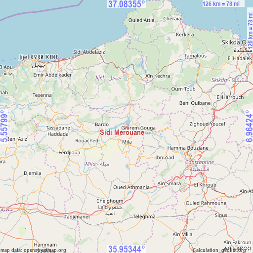
Sidi Mérouane GPS coordinates[2]
36° 31' 14.016" North, 6° 15' 39.996" East
| Map corner | latitude | longitude |
|---|---|---|
| Upper-left | 37.08355°, | 5.55799° |
| Center: | 36.52056°, | 6.26111° |
| Lower-right: | 35.95344°, | 6.96424° |
| Map W x H: | 125.7×125.7 km | = 78.1×78.1mi |
| max Lat: | 36.92917° ⇑30.2% North |
| Sidi Mérouane: | 36.52056° |
| min Lat: | ⇓69.8% South 22.785° |
| min Long | Sidi Mérouane | max Long |
| -8.14743° | 6.26111° | 8.46667° |
| W 83.3%⇐ | ⇒16.7% E |
Elevation
Elevation of Sidi Mérouane is 289 m = 948 ft, and this is 149.5 m = 490 ft below average elevation for this country.
| Max E: |
1392 m = 4567 ft | 50.8% |
| Avg. | 438.5 m = 1439 ft | |
| Sidi Mérouane | 289 m = 948 ft | |
Min E: |
5 m = 16 ft | 49.2% |
See also: Algeria elevation on elevation.city.
Geographical zone
Sidi Mérouane is located in North temperate zone (between Tropic of Cancer and the Arctic Circle). Distance of this Northern Tropic circle is 1454.8 km =904 mi to South.| Distance of | km | miles | from Sidi Mérouane |
|---|---|---|---|
| North Pole | 5946.4 | 3694.9 | to North |
| Arctic Circle | 3340.5 | 2075.7 | to North |
| Tropic Cancer | 1454.8 | 904 | to South |
| Equator | 4060.7 | 2523.2 | to South |


Nearby cities:
15 places around Sidi Mérouane: (largest is in red/bold)
• Aïn Smara
35.4 km =22 mi,  142°
142°
• BABOR - VILLE
64.6 km =40.1 mi,  266°
266°
• Chelghoum el Aïd
40.7 km =25.3 mi,  192°
192°
• Constantine
36 km =22.4 mi,  118°
118°
• Didouche Mourad
34.4 km =21.4 mi,  102°
102°
• El Eulma
65.5 km =40.7 mi,  231°
231°
• El Khroub
48.1 km =29.9 mi,  126°
126°
• Hamma Bouziane
32.3 km =20.1 mi,  111°
111°
• Jijel
55.3 km =34.4 mi,  307°
307°
• Karkira
53.9 km =33.5 mi,  32°
32°
• Mila
7.8 km =4.8 mi,  177°
177°
• Rouached
20.7 km =12.9 mi,  250°
250°
• Tamalous
48.8 km =30.3 mi,  43°
43°
• Telerghma
45.7 km =28.4 mi,  169°
169°
• ’Aïn Abid
69 km =42.9 mi, 117°
Sources, notices
• [Note1] Compared only with cities in Algeria existing in our database
• [Src1] Map data: © OpenStreetMap contributors (CC-BY-SA)
• [Src2] Other city data from geonames.org with taken over terms of usage.
• [Src3] Geographical zone / Annual Mean Temperature by Robert A. Rohde @ Wikipedia
