Tamalous geodata
Tamalous (Skikda) is a populated place; located in Algeria in Africa/Algiers (GMT+1) time zone. With population of 32,579 people, there are 158 cities with bigger population in this country. Compared to other cities in Algeria, 98.1% of cities are located further ↓South; 87.2% of cities are located further ←West and 83.3% of cities have higher elevation than Tamalous. Note1


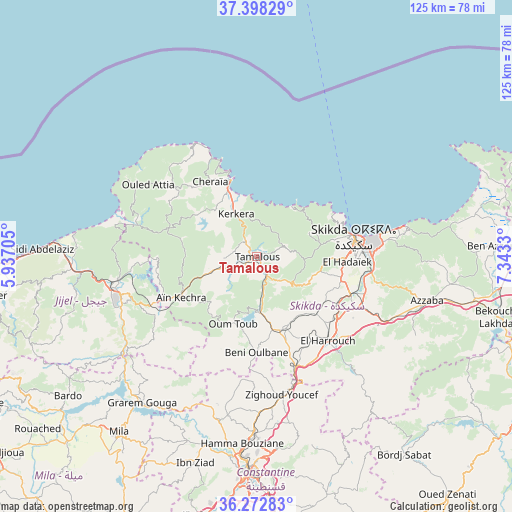
Tamalous GPS coordinates[2]
36° 50' 15.468" North, 6° 38' 24.648" East
| Map corner | latitude | longitude |
|---|---|---|
| Upper-left | 37.39829°, | 5.93705° |
| Center: | 36.83763°, | 6.64018° |
| Lower-right: | 36.27283°, | 7.3433° |
| Map W x H: | 125.1×125.1 km | = 77.7×77.7mi |
| max Lat: | 36.92917° ⇑1.9% North |
| Tamalous: | 36.83763° |
| min Lat: | ⇓98.1% South 22.785° |
| min Long | Tamalous | max Long |
| -8.14743° | 6.64018° | 8.46667° |
| W 87.2%⇐ | ⇒12.8% E |
Elevation
Elevation of Tamalous is 65 m = 213 ft, and this is 373.5 m = 1225 ft below average elevation for this country.
| Max E: |
1392 m = 4567 ft | 83.3% |
| Avg. | 438.5 m = 1439 ft | |
| Tamalous | 65 m = 213 ft | |
Min E: |
5 m = 16 ft | 16.7% |
See also: Algeria elevation on elevation.city.
Geographical zone
Tamalous is located in North temperate zone (between Tropic of Cancer and the Arctic Circle). Distance of this Northern Tropic circle is 1490 km =925.8 mi to South.| Distance of | km | miles | from Tamalous |
|---|---|---|---|
| North Pole | 5911.1 | 3673 | to North |
| Arctic Circle | 3305.2 | 2053.8 | to North |
| Tropic Cancer | 1490 | 925.8 | to South |
| Equator | 4096 | 2545.1 | to South |


Nearby cities:
15 places around Tamalous: (largest is in red/bold)
• Azzaba
42.8 km =26.6 mi,  104°
104°
• Aïn Smara
64.6 km =40.1 mi,  191°
191°
• Berrahal
72.4 km =45 mi,  90°
90°
• Constantine
52.6 km =32.7 mi,  182°
182°
• Didouche Mourad
42.8 km =26.6 mi, 180°
• El Khroub
64 km =39.8 mi, 175°
• Hamma Bouziane
47.5 km =29.5 mi, 184°
• Héliopolis
80.6 km =50.1 mi,  117°
117°
• Jijel
77.8 km =48.3 mi,  268°
268°
• Karkira
11.3 km =7 mi,  334°
334°
• Mila
54.6 km =33.9 mi,  217°
217°
• Rouached
68 km =42.3 mi,  231°
231°
• Sidi Mérouane
48.8 km =30.3 mi, 223°
• Skikda
24.3 km =15.1 mi,  79°
79°
• ’Aïn Abid
72.6 km =45.1 mi,  158°
158°
Sources, notices
• [Note1] Compared only with cities in Algeria existing in our database
• [Src1] Map data: © OpenStreetMap contributors (CC-BY-SA)
• [Src2] Other city data from geonames.org with taken over terms of usage.
• [Src3] Geographical zone / Annual Mean Temperature by Robert A. Rohde @ Wikipedia
