’Aïn Abid geodata
’Aïn Abid (Constantine) is a populated place; located in Algeria in Africa/Algiers (GMT+1) time zone. With population of 29,486 people, there are 177 cities with bigger population in this country. Compared to other cities in Algeria, 57% of cities are located further ↓South; 90.3% of cities are located further ←West and 80.6% of cities have lower elevation than ’Aïn Abid. Note1


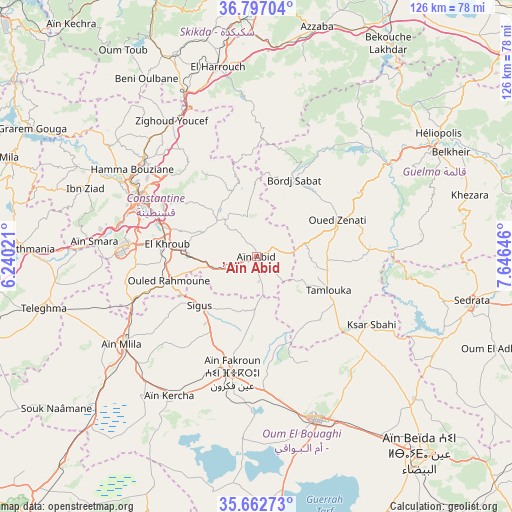
’Aïn Abid GPS coordinates[2]
36° 13' 54.984" North, 6° 56' 35.988" East
| Map corner | latitude | longitude |
|---|---|---|
| Upper-left | 36.79704°, | 6.24021° |
| Center: | 36.23194°, | 6.94333° |
| Lower-right: | 35.66273°, | 7.64646° |
| Map W x H: | 126.1×126.1 km | = 78.4×78.4mi |
| max Lat: | 36.92917° ⇑43% North |
| ’Aïn Abid: | 36.23194° |
| min Lat: | ⇓57% South 22.785° |
| min Long | ’Aïn Abid | max Long |
| -8.14743° | 6.94333° | 8.46667° |
| W 90.3%⇐ | ⇒9.7% E |
Elevation
Elevation of ’Aïn Abid is 868 m = 2848 ft, and this is 429.5 m = 1409 ft above average elevation for this country.
| Max E: |
1392 m = 4567 ft | 19.4% |
| ’Aïn Abid | 868 m 2848 ft | |
| Avg. | 438.5 m = 1439 ft | |
Min E: |
5 m = 16 ft | 80.6% |
See also: Algeria elevation on elevation.city.
Geographical zone
’Aïn Abid is located in North temperate zone (between Tropic of Cancer and the Arctic Circle). Distance of this Northern Tropic circle is 1422.7 km =884 mi to South.| Distance of | km | miles | from ’Aïn Abid |
|---|---|---|---|
| North Pole | 5978.4 | 3714.8 | to North |
| Arctic Circle | 3372.6 | 2095.6 | to North |
| Tropic Cancer | 1422.7 | 884 | to South |
| Equator | 4028.6 | 2503.3 | to South |


Nearby cities:
15 places around ’Aïn Abid: (largest is in red/bold)
• Azzaba
58.3 km =36.2 mi,  14°
14°
• Aïn Beïda
63.1 km =39.2 mi,  140°
140°
• Aïn Fakroun
29.7 km =18.5 mi,  192°
192°
• Aïn Kercha
40.8 km =25.4 mi,  213°
213°
• Aïn Smara
39.8 km =24.7 mi,  275°
275°
• Boumahra Ahmed
57 km =35.4 mi,  63°
63°
• Constantine
33 km =20.5 mi,  296°
296°
• Didouche Mourad
36.8 km =22.9 mi,  311°
311°
• El Khroub
22.7 km =14.1 mi, 278°
• Guelma
50.2 km =31.2 mi, 59°
• Hamma Bouziane
37 km =23 mi, 302°
• Héliopolis
54 km =33.6 mi, 55°
• Oum el Bouaghi
42.5 km =26.4 mi,  158°
158°
• Sedrata
54.2 km =33.7 mi,  102°
102°
• Telerghma
54.4 km =33.8 mi,  256°
256°
Sources, notices
• [Note1] Compared only with cities in Algeria existing in our database
• [Src1] Map data: © OpenStreetMap contributors (CC-BY-SA)
• [Src2] Other city data from geonames.org with taken over terms of usage.
• [Src3] Geographical zone / Annual Mean Temperature by Robert A. Rohde @ Wikipedia
