Berrahal geodata
Berrahal (Annaba) is a populated place; located in Algeria in Africa/Algiers (GMT+1) time zone. With population of 19,294 people, there are 235 cities with bigger population in this country. Compared to other cities in Algeria, 97.7% of cities are located further ↓South; 93.4% of cities are located further ←West and 92.2% of cities have higher elevation than Berrahal. Note1


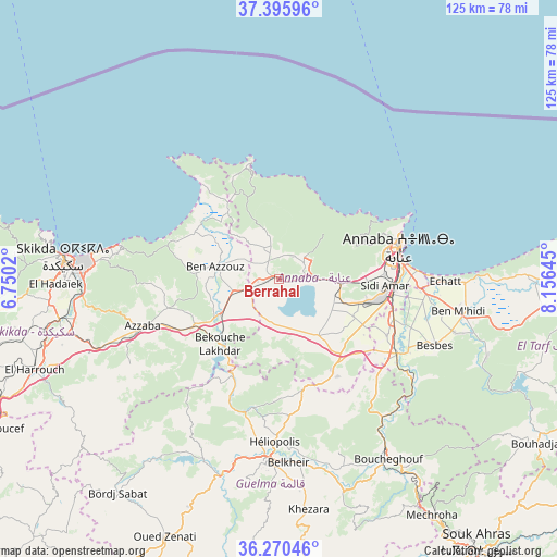
Berrahal GPS coordinates[2]
36° 50' 7.008" North, 7° 27' 11.988" East
| Map corner | latitude | longitude |
|---|---|---|
| Upper-left | 37.39596°, | 6.7502° |
| Center: | 36.83528°, | 7.45333° |
| Lower-right: | 36.27046°, | 8.15645° |
| Map W x H: | 125.1×125.1 km | = 77.7×77.7mi |
| max Lat: | 36.92917° ⇑2.3% North |
| Berrahal: | 36.83528° |
| min Lat: | ⇓97.7% South 22.785° |
| min Long | Berrahal | max Long |
| -8.14743° | 7.45333° | 8.46667° |
| W 93.4%⇐ | ⇒6.6% E |
Elevation
Elevation of Berrahal is 30 m = 98 ft, and this is 408.5 m = 1340 ft below average elevation for this country.
| Max E: |
1392 m = 4567 ft | 92.2% |
| Avg. | 438.5 m = 1439 ft | |
| Berrahal | 30 m = 98 ft | |
Min E: |
5 m = 16 ft | 7.8% |
See also: Algeria elevation on elevation.city.
Geographical zone
Berrahal is located in North temperate zone (between Tropic of Cancer and the Arctic Circle). Distance of this Northern Tropic circle is 1489.8 km =925.7 mi to South.| Distance of | km | miles | from Berrahal |
|---|---|---|---|
| North Pole | 5911.4 | 3673.2 | to North |
| Arctic Circle | 3305.5 | 2053.9 | to North |
| Tropic Cancer | 1489.8 | 925.7 | to South |
| Equator | 4095.7 | 2544.9 | to South |


Nearby cities:
15 places around Berrahal: (largest is in red/bold)
• Annaba
28.8 km =17.9 mi,  75°
75°
• Azzaba
32.8 km =20.4 mi,  251°
251°
• Ben Mehidi
41 km =25.5 mi,  100°
100°
• Besbes
38.1 km =23.7 mi,  112°
112°
• Boumahra Ahmed
42.3 km =26.3 mi,  172°
172°
• Drean
31.4 km =19.5 mi,  122°
122°
• El Hadjar
25.5 km =15.8 mi, 97°
• El Tarf
77 km =47.8 mi, 95°
• Guelma
41.6 km =25.8 mi,  183°
183°
• Héliopolis
36.9 km =22.9 mi, 181°
• Karkira
77.9 km =48.4 mi,  277°
277°
• Sedrata
78.9 km =49 mi, 174°
• Skikda
48.6 km =30.2 mi, 275°
• Souk Ahras
75.5 km =46.9 mi,  143°
143°
• Tamalous
72.4 km =45 mi,  270°
270°
Sources, notices
• [Note1] Compared only with cities in Algeria existing in our database
• [Src1] Map data: © OpenStreetMap contributors (CC-BY-SA)
• [Src2] Other city data from geonames.org with taken over terms of usage.
• [Src3] Geographical zone / Annual Mean Temperature by Robert A. Rohde @ Wikipedia
