Constantine geodata
Constantine is a seat of a first-order administrative division; located in Algeria in Africa/Algiers (GMT+1) time zone. With population of 450,097 people, there are 4 cities with bigger population in this country. Compared to other cities in Algeria, 61.2% of cities are located further ↓South; 86.4% of cities are located further ←West and 65.5% of cities have lower elevation than Constantine. Note1


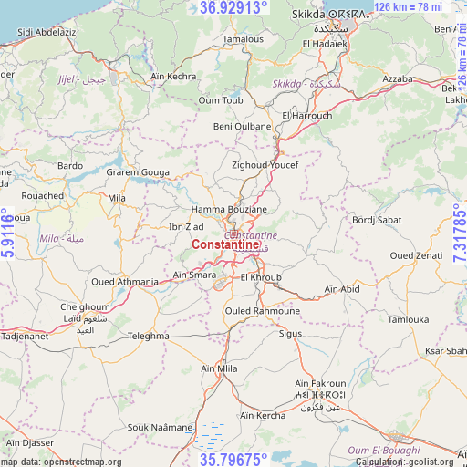
Constantine GPS coordinates[2]
36° 21' 54" North, 6° 36' 52.992" East
| Map corner | latitude | longitude |
|---|---|---|
| Upper-left | 36.92913°, | 5.9116° |
| Center: | 36.365°, | 6.61472° |
| Lower-right: | 35.79675°, | 7.31785° |
| Map W x H: | 125.9×125.9 km | = 78.2×78.2mi |
| max Lat: | 36.92917° ⇑38.8% North |
| Constantine: | 36.365° |
| min Lat: | ⇓61.2% South 22.785° |
| min Long | Constantine | max Long |
| -8.14743° | 6.61472° | 8.46667° |
| W 86.4%⇐ | ⇒13.6% E |
Elevation
Elevation of Constantine is 574 m = 1883 ft, and this is 135.5 m = 445 ft above average elevation for this country.
| Max E: |
1392 m = 4567 ft | 34.5% |
| Constantine | 574 m 1883 ft | |
| Avg. | 438.5 m = 1439 ft | |
Min E: |
5 m = 16 ft | 65.5% |
See also: Constantine elevation on elevation.city.
Geographical zone
Constantine is located in North temperate zone (between Tropic of Cancer and the Arctic Circle). Distance of this Northern Tropic circle is 1437.5 km =893.2 mi to South.| Distance of | km | miles | from Constantine |
|---|---|---|---|
| North Pole | 5963.7 | 3705.7 | to North |
| Arctic Circle | 3357.8 | 2086.4 | to North |
| Tropic Cancer | 1437.5 | 893.2 | to South |
| Equator | 4043.4 | 2512.5 | to South |


Nearby cities:
15 places around Constantine: (largest is in red/bold)
• Azzaba
60.4 km =37.5 mi,  46°
46°
• Aïn Fakroun
49.6 km =30.8 mi,  152°
152°
• Aïn Kercha
49.5 km =30.8 mi,  171°
171°
• Aïn Smara
14.9 km =9.3 mi,  223°
223°
• Chelghoum el Aïd
46 km =28.6 mi,  240°
240°
• Didouche Mourad
9.9 km =6.2 mi,  11°
11°
• El Khroub
13.3 km =8.3 mi, 147°
• Hamma Bouziane
5.5 km =3.4 mi,  342°
342°
• Mila
32.7 km =20.3 mi,  286°
286°
• Rouached
52.2 km =32.4 mi,  281°
281°
• Sidi Mérouane
36 km =22.4 mi,  298°
298°
• Skikda
62.6 km =38.9 mi,  24°
24°
• Tamalous
52.6 km =32.7 mi,  2°
2°
• Telerghma
36.2 km =22.5 mi, 220°
• ’Aïn Abid
33 km =20.5 mi,  116°
116°
In other languages:
- In Spanish: Constantina
- In Italian: Constantina
- In Russian: Константина
- In Chinese: 君士坦丁
Sources, notices
• [Note1] Compared only with cities in Algeria existing in our database
• [Src1] Map data: © OpenStreetMap contributors (CC-BY-SA)
• [Src2] Other city data from geonames.org with taken over terms of usage.
• [Src3] Geographical zone / Annual Mean Temperature by Robert A. Rohde @ Wikipedia
