Héliopolis geodata
Héliopolis (Guelma) is a populated place; located in Algeria in Africa/Algiers (GMT+1) time zone. With population of 40,139 people, there are 128 cities with bigger population in this country. Compared to other cities in Algeria, 68.6% of cities are located further ↓South; 93% of cities are located further ←West and 52.7% of cities have higher elevation than Héliopolis. Note1


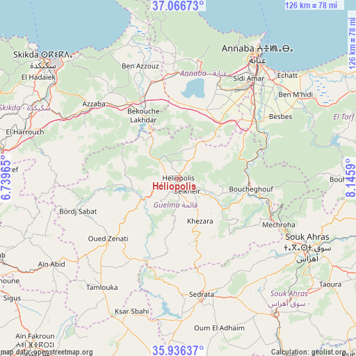
Héliopolis GPS coordinates[2]
36° 30' 12.996" North, 7° 26' 34.008" East
| Map corner | latitude | longitude |
|---|---|---|
| Upper-left | 37.06673°, | 6.73965° |
| Center: | 36.50361°, | 7.44278° |
| Lower-right: | 35.93637°, | 8.1459° |
| Map W x H: | 125.7×125.7 km | = 78.1×78.1mi |
| max Lat: | 36.92917° ⇑31.4% North |
| Héliopolis: | 36.50361° |
| min Lat: | ⇓68.6% South 22.785° |
| min Long | Héliopolis | max Long |
| -8.14743° | 7.44278° | 8.46667° |
| W 93%⇐ | ⇒7% E |
Elevation
Elevation of Héliopolis is 268 m = 879 ft, and this is 170.5 m = 559 ft below average elevation for this country.
| Max E: |
1392 m = 4567 ft | 52.7% |
| Avg. | 438.5 m = 1439 ft | |
| Héliopolis | 268 m = 879 ft | |
Min E: |
5 m = 16 ft | 47.3% |
See also: Héliopolis elevation on elevation.city.
Geographical zone
Héliopolis is located in North temperate zone (between Tropic of Cancer and the Arctic Circle). Distance of this Northern Tropic circle is 1452.9 km =902.8 mi to South.| Distance of | km | miles | from Héliopolis |
|---|---|---|---|
| North Pole | 5948.2 | 3696 | to North |
| Arctic Circle | 3342.4 | 2076.9 | to North |
| Tropic Cancer | 1452.9 | 902.8 | to South |
| Equator | 4058.8 | 2522 | to South |


Nearby cities:
15 places around Héliopolis: (largest is in red/bold)
• Annaba
52.7 km =32.7 mi,  33°
33°
• Azzaba
39.9 km =24.8 mi,  311°
311°
• Ben Mehidi
50.9 km =31.6 mi,  54°
54°
• Berrahal
36.9 km =22.9 mi,  1°
1°
• Besbes
42.3 km =26.3 mi,  58°
58°
• Boumahra Ahmed
8.1 km =5 mi,  128°
128°
• Didouche Mourad
72.3 km =44.9 mi,  265°
265°
• Drean
34.1 km =21.2 mi, 53°
• El Hadjar
42.4 km =26.3 mi,  38°
38°
• El Khroub
72.2 km =44.9 mi,  248°
248°
• Guelma
4.8 km =3 mi,  197°
197°
• Sedrata
42.5 km =26.4 mi,  168°
168°
• Skikda
63.1 km =39.2 mi, 311°
• Souk Ahras
51.5 km =32 mi,  117°
117°
• ’Aïn Abid
54 km =33.6 mi,  235°
235°
Sources, notices
• [Note1] Compared only with cities in Algeria existing in our database
• [Src1] Map data: © OpenStreetMap contributors (CC-BY-SA)
• [Src2] Other city data from geonames.org with taken over terms of usage.
• [Src3] Geographical zone / Annual Mean Temperature by Robert A. Rohde @ Wikipedia
