Mila geodata
Mila is a seat of a first-order administrative division; located in Algeria in Africa/Algiers (GMT+1) time zone. With population of 68,831 people, there are 60 cities with bigger population in this country. Compared to other cities in Algeria, 63.2% of cities are located further ↓South; 83.7% of cities are located further ←West and 57.8% of cities have lower elevation than Mila. Note1


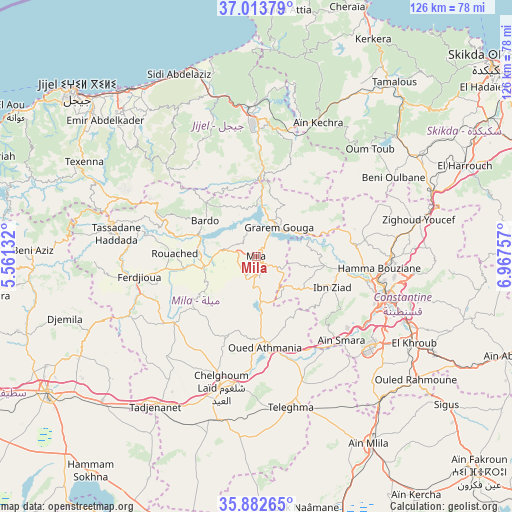
Mila GPS coordinates[2]
36° 27' 1.008" North, 6° 15' 51.984" East
| Map corner | latitude | longitude |
|---|---|---|
| Upper-left | 37.01379°, | 5.56132° |
| Center: | 36.45028°, | 6.26444° |
| Lower-right: | 35.88265°, | 6.96757° |
| Map W x H: | 125.8×125.8 km | = 78.2×78.2mi |
| max Lat: | 36.92917° ⇑36.8% North |
| Mila: | 36.45028° |
| min Lat: | ⇓63.2% South 22.785° |
| min Long | Mila | max Long |
| -8.14743° | 6.26444° | 8.46667° |
| W 83.7%⇐ | ⇒16.3% E |
Elevation
Elevation of Mila is 470 m = 1542 ft, and this is 31.5 m = 103 ft above average elevation for this country.
| Max E: |
1392 m = 4567 ft | 42.2% |
| Mila | 470 m 1542 ft | |
| Avg. | 438.5 m = 1439 ft | |
Min E: |
5 m = 16 ft | 57.8% |
See also: Mila elevation on elevation.city.
Geographical zone
Mila is located in North temperate zone (between Tropic of Cancer and the Arctic Circle). Distance of this Northern Tropic circle is 1447 km =899.1 mi to South.| Distance of | km | miles | from Mila |
|---|---|---|---|
| North Pole | 5954.2 | 3699.8 | to North |
| Arctic Circle | 3348.3 | 2080.5 | to North |
| Tropic Cancer | 1447 | 899.1 | to South |
| Equator | 4052.9 | 2518.4 | to South |


Nearby cities:
15 places around Mila: (largest is in red/bold)
• Aïn Smara
29.4 km =18.3 mi,  133°
133°
• BABOR - VILLE
65 km =40.4 mi,  273°
273°
• Chelghoum el Aïd
33.1 km =20.6 mi,  195°
195°
• Constantine
32.7 km =20.3 mi,  106°
106°
• Didouche Mourad
33.3 km =20.7 mi,  89°
89°
• El Eulma
61.2 km =38 mi,  237°
237°
• El Khroub
43.7 km =27.2 mi,  118°
118°
• Hamma Bouziane
30 km =18.6 mi,  98°
98°
• Jijel
60.6 km =37.7 mi,  312°
312°
• Karkira
60.5 km =37.6 mi,  28°
28°
• Rouached
19.9 km =12.4 mi, 272°
• Sidi Mérouane
7.8 km =4.8 mi,  357°
357°
• Tamalous
54.6 km =33.9 mi,  37°
37°
• Telerghma
38 km =23.6 mi,  167°
167°
• ’Aïn Abid
65.5 km =40.7 mi, 111°
Sources, notices
• [Note1] Compared only with cities in Algeria existing in our database
• [Src1] Map data: © OpenStreetMap contributors (CC-BY-SA)
• [Src2] Other city data from geonames.org with taken over terms of usage.
• [Src3] Geographical zone / Annual Mean Temperature by Robert A. Rohde @ Wikipedia
