Meftah geodata
Meftah (Blida) is a populated place; located in Algeria in Africa/Algiers (GMT+1) time zone. With population of 59,990 people, there are 77 cities with bigger population in this country. Compared to other cities in Algeria, 78.3% of cities are located further ↓South; 55% of cities are located further →East and 81.4% of cities have higher elevation than Meftah. Note1


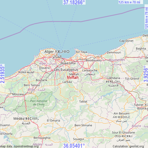
Meftah GPS coordinates[2]
36° 37' 13.44" North, 3° 13' 20.928" East
| Map corner | latitude | longitude |
|---|---|---|
| Upper-left | 37.18266°, | 2.51935° |
| Center: | 36.6204°, | 3.22248° |
| Lower-right: | 36.05401°, | 3.9256° |
| Map W x H: | 125.5×125.5 km | = 78×78mi |
| max Lat: | 36.92917° ⇑21.7% North |
| Meftah: | 36.6204° |
| min Lat: | ⇓78.3% South 22.785° |
| min Long | Meftah | max Long |
| -8.14743° | 3.22248° | 8.46667° |
| W 45%⇐ | ⇒55% E |
Elevation
Elevation of Meftah is 78 m = 256 ft, and this is 360.5 m = 1183 ft below average elevation for this country.
| Max E: |
1392 m = 4567 ft | 81.4% |
| Avg. | 438.5 m = 1439 ft | |
| Meftah | 78 m = 256 ft | |
Min E: |
5 m = 16 ft | 18.6% |
See also: Meftah elevation on elevation.city.
Geographical zone
Meftah is located in North temperate zone (between Tropic of Cancer and the Arctic Circle). Distance of this Northern Tropic circle is 1465.9 km =910.9 mi to South.| Distance of | km | miles | from Meftah |
|---|---|---|---|
| North Pole | 5935.3 | 3688 | to North |
| Arctic Circle | 3329.4 | 2068.8 | to North |
| Tropic Cancer | 1465.9 | 910.9 | to South |
| Equator | 4071.8 | 2530.1 | to South |


Nearby cities:
15 places around Meftah: (largest is in red/bold)
• Algiers
17.3 km =10.7 mi,  315°
315°
• Arbatache
13.4 km =8.3 mi,  81°
81°
• Bab Ezzouar
12.3 km =7.6 mi,  343°
343°
• Baraki
12.4 km =7.7 mi,  294°
294°
• Birkhadem
18.6 km =11.6 mi,  304°
304°
• Bordj el Kiffan
14.5 km =9 mi,  349°
349°
• Bougara
15.4 km =9.6 mi,  235°
235°
• Chebli
19.6 km =12.2 mi,  255°
255°
• Dar el Beïda
10.4 km =6.5 mi,  355°
355°
• Khemis el Khechna
10.2 km =6.3 mi,  71°
71°
• Larbaâ
8.7 km =5.4 mi,  224°
224°
• Ouled Moussa
14.7 km =9.1 mi,  61°
61°
• Reghaïa
16.6 km =10.3 mi,  39°
39°
• Rouiba
14.1 km =8.8 mi,  21°
21°
• Sidi Moussa
12.1 km =7.5 mi, 262°
Sources, notices
• [Note1] Compared only with cities in Algeria existing in our database
• [Src1] Map data: © OpenStreetMap contributors (CC-BY-SA)
• [Src2] Other city data from geonames.org with taken over terms of usage.
• [Src3] Geographical zone / Annual Mean Temperature by Robert A. Rohde @ Wikipedia
