Birkhadem geodata
Birkhadem (Algiers) is a populated place; located in Algeria in Africa/Algiers (GMT+1) time zone. With population of 71,722 people, there are 56 cities with bigger population in this country. Compared to other cities in Algeria, 87.2% of cities are located further ↓South; 58.9% of cities are located further →East and 76.4% of cities have higher elevation than Birkhadem. Note1


Birkhadem GPS coordinates[2]
36° 42' 53.964" North, 3° 3' 0.072" East
| Map corner | latitude | longitude |
|---|---|---|
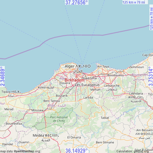
| Upper-left | 37.27656°, | 2.34689° |
| Center: | 36.71499°, | 3.05002° |
| Lower-right: | 36.14929°, | 3.75314° |
| Map W x H: | 125.3×125.3 km | = 77.9×77.9mi |
| max Lat: | 36.92917° ⇑12.8% North |
| Birkhadem: | 36.71499° |
| min Lat: | ⇓87.2% South 22.785° |
| min Long | Birkhadem | max Long |
| -8.14743° | 3.05002° | 8.46667° |
| W 41.1%⇐ | ⇒58.9% E |
Elevation
Elevation of Birkhadem is 94 m = 308 ft, and this is 344.5 m = 1130 ft below average elevation for this country.
| Max E: |
1392 m = 4567 ft | 76.4% |
| Avg. | 438.5 m = 1439 ft | |
| Birkhadem | 94 m = 308 ft | |
Min E: |
5 m = 16 ft | 23.6% |
See also: Birkhadem elevation on elevation.city.
Geographical zone
Birkhadem is located in North temperate zone (between Tropic of Cancer and the Arctic Circle). Distance of this Northern Tropic circle is 1476.4 km =917.4 mi to South.| Distance of | km | miles | from Birkhadem |
|---|---|---|---|
| North Pole | 5924.7 | 3681.4 | to North |
| Arctic Circle | 3318.8 | 2062.2 | to North |
| Tropic Cancer | 1476.4 | 917.4 | to South |
| Equator | 4082.3 | 2536.6 | to South |


Nearby cities:
15 places around Birkhadem: (largest is in red/bold)
• Algiers
3.8 km =2.4 mi,  60°
60°
• Bab Ezzouar
11.9 km =7.4 mi,  84°
84°
• Baraki
6.8 km =4.2 mi,  142°
142°
• Bordj el Kiffan
13.2 km =8.2 mi,  73°
73°
• Bougara
19.5 km =12.1 mi,  171°
171°
• Chebli
15.7 km =9.8 mi,  193°
193°
• Cheraga
10 km =6.2 mi,  305°
305°
• Dar el Beïda
14.5 km =9 mi,  90°
90°
• Douera
10.7 km =6.6 mi,  242°
242°
• Larbaâ
19.1 km =11.9 mi,  150°
150°
• Meftah
18.6 km =11.6 mi,  124°
124°
• Saoula
2.5 km =1.6 mi, 242°
• Sidi Moussa
12.5 km =7.8 mi,  164°
164°
• Zeralda
18.5 km =11.5 mi,  268°
268°
• ’Aïn Benian
15 km =9.3 mi, 310°
Sources, notices
• [Note1] Compared only with cities in Algeria existing in our database
• [Src1] Map data: © OpenStreetMap contributors (CC-BY-SA)
• [Src2] Other city data from geonames.org with taken over terms of usage.
• [Src3] Geographical zone / Annual Mean Temperature by Robert A. Rohde @ Wikipedia
