Baraki geodata
Baraki (Tipaza) is a populated place; located in Algeria in Africa/Algiers (GMT+1) time zone. With population of 105,402 people, there are 39 cities with bigger population in this country. Compared to other cities in Algeria, 82.2% of cities are located further ↓South; 57.4% of cities are located further →East and 95% of cities have higher elevation than Baraki. Note1


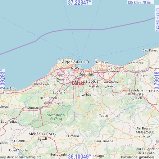
Baraki GPS coordinates[2]
36° 39' 59.58" North, 3° 5' 45.816" East
| Map corner | latitude | longitude |
|---|---|---|
| Upper-left | 37.22847°, | 2.39293° |
| Center: | 36.66655°, | 3.09606° |
| Lower-right: | 36.10049°, | 3.79918° |
| Map W x H: | 125.4×125.4 km | = 77.9×77.9mi |
| max Lat: | 36.92917° ⇑17.8% North |
| Baraki: | 36.66655° |
| min Lat: | ⇓82.2% South 22.785° |
| min Long | Baraki | max Long |
| -8.14743° | 3.09606° | 8.46667° |
| W 42.6%⇐ | ⇒57.4% E |
Elevation
Elevation of Baraki is 22 m = 72 ft, and this is 416.5 m = 1366 ft below average elevation for this country.
| Max E: |
1392 m = 4567 ft | 95% |
| Avg. | 438.5 m = 1439 ft | |
| Baraki | 22 m = 72 ft | |
Min E: |
5 m = 16 ft | 5% |
See also: Baraki elevation on elevation.city.
Geographical zone
Baraki is located in North temperate zone (between Tropic of Cancer and the Arctic Circle). Distance of this Northern Tropic circle is 1471 km =914 mi to South.| Distance of | km | miles | from Baraki |
|---|---|---|---|
| North Pole | 5930.1 | 3684.8 | to North |
| Arctic Circle | 3324.2 | 2065.6 | to North |
| Tropic Cancer | 1471 | 914 | to South |
| Equator | 4076.9 | 2533.3 | to South |


Nearby cities:
15 places around Baraki: (largest is in red/bold)
• Algiers
7.3 km =4.5 mi,  354°
354°
• Bab Ezzouar
10.2 km =6.3 mi,  49°
49°
• Birkhadem
6.8 km =4.2 mi,  322°
322°
• Bordj el Kiffan
12.5 km =7.8 mi,  43°
43°
• Bougara
13.9 km =8.6 mi,  185°
185°
• Bouinan
17.6 km =10.9 mi,  211°
211°
• Chebli
12.6 km =7.8 mi,  217°
217°
• Cheraga
16.6 km =10.3 mi,  312°
312°
• Dar el Beïda
11.6 km =7.2 mi,  63°
63°
• Douera
13.5 km =8.4 mi,  271°
271°
• Larbaâ
12.5 km =7.8 mi,  155°
155°
• Meftah
12.4 km =7.7 mi,  114°
114°
• Rouiba
18.3 km =11.4 mi, 64°
• Saoula
7.6 km =4.7 mi,  303°
303°
• Sidi Moussa
6.7 km =4.2 mi, 186°
Sources, notices
• [Note1] Compared only with cities in Algeria existing in our database
• [Src1] Map data: © OpenStreetMap contributors (CC-BY-SA)
• [Src2] Other city data from geonames.org with taken over terms of usage.
• [Src3] Geographical zone / Annual Mean Temperature by Robert A. Rohde @ Wikipedia
