Ouled Moussa geodata
Ouled Moussa (Boumerdes) is a populated place; located in Algeria in Africa/Algiers (GMT+1) time zone. With population of 13,474 people, there are 246 cities with bigger population in this country. Compared to other cities in Algeria, 84.5% of cities are located further ↓South; 51.9% of cities are located further →East and 70.5% of cities have higher elevation than Ouled Moussa. Note1


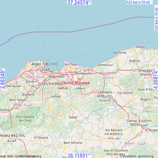
Ouled Moussa GPS coordinates[2]
36° 41' 2.184" North, 3° 21' 59.796" East
| Map corner | latitude | longitude |
|---|---|---|
| Upper-left | 37.24574°, | 2.66349° |
| Center: | 36.68394°, | 3.36661° |
| Lower-right: | 36.11801°, | 4.06974° |
| Map W x H: | 125.4×125.4 km | = 77.9×77.9mi |
| max Lat: | 36.92917° ⇑15.5% North |
| Ouled Moussa: | 36.68394° |
| min Lat: | ⇓84.5% South 22.785° |
| min Long | Ouled Moussa | max Long |
| -8.14743° | 3.36661° | 8.46667° |
| W 48.1%⇐ | ⇒51.9% E |
Elevation
Elevation of Ouled Moussa is 115 m = 377 ft, and this is 323.5 m = 1061 ft below average elevation for this country.
| Max E: |
1392 m = 4567 ft | 70.5% |
| Avg. | 438.5 m = 1439 ft | |
| Ouled Moussa | 115 m = 377 ft | |
Min E: |
5 m = 16 ft | 29.5% |
See also: Algeria elevation on elevation.city.
Geographical zone
Ouled Moussa is located in North temperate zone (between Tropic of Cancer and the Arctic Circle). Distance of this Northern Tropic circle is 1473 km =915.3 mi to South.| Distance of | km | miles | from Ouled Moussa |
|---|---|---|---|
| North Pole | 5928.2 | 3683.6 | to North |
| Arctic Circle | 3322.3 | 2064.4 | to North |
| Tropic Cancer | 1473 | 915.3 | to South |
| Equator | 4078.9 | 2534.5 | to South |


Nearby cities:
15 places around Ouled Moussa: (largest is in red/bold)
• Arbatache
5.2 km =3.2 mi,  175°
175°
• Aïn Taya
14.1 km =8.8 mi,  329°
329°
• Bab Ezzouar
17 km =10.6 mi,  285°
285°
• Beni Amrane
20.1 km =12.5 mi,  95°
95°
• Bordj el Kiffan
17.1 km =10.6 mi, 294°
• Boudouaou
6.2 km =3.9 mi,  38°
38°
• Boumerdas
13.5 km =8.4 mi,  47°
47°
• Dar el Beïda
14.1 km =8.8 mi,  283°
283°
• Khemis el Khechna
4.9 km =3 mi,  220°
220°
• Lakhdaria
24.2 km =15 mi,  123°
123°
• Larbaâ
23.1 km =14.4 mi,  235°
235°
• Meftah
14.7 km =9.1 mi, 241°
• Reghaïa
6.2 km =3.9 mi,  337°
337°
• Rouiba
9.7 km =6 mi,  308°
308°
• Thenia
17.6 km =10.9 mi,  74°
74°
Sources, notices
• [Note1] Compared only with cities in Algeria existing in our database
• [Src1] Map data: © OpenStreetMap contributors (CC-BY-SA)
• [Src2] Other city data from geonames.org with taken over terms of usage.
• [Src3] Geographical zone / Annual Mean Temperature by Robert A. Rohde @ Wikipedia
