Lakhdaria geodata
Lakhdaria (Bouira) is a populated place; located in Algeria in Africa/Algiers (GMT+1) time zone. With population of 56,719 people, there are 85 cities with bigger population in this country. Compared to other cities in Algeria, 73.6% of cities are located further ↓South; 51.2% of cities are located further ←West and 60.9% of cities have higher elevation than Lakhdaria. Note1


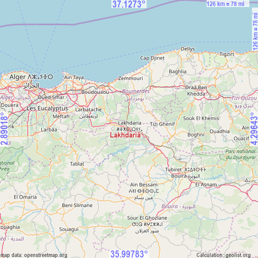
Lakhdaria GPS coordinates[2]
36° 33' 52.668" North, 3° 35' 35.88" East
| Map corner | latitude | longitude |
|---|---|---|
| Upper-left | 37.1273°, | 2.89018° |
| Center: | 36.56463°, | 3.5933° |
| Lower-right: | 35.99783°, | 4.29643° |
| Map W x H: | 125.6×125.6 km | = 78×78mi |
| max Lat: | 36.92917° ⇑26.4% North |
| Lakhdaria: | 36.56463° |
| min Lat: | ⇓73.6% South 22.785° |
| min Long | Lakhdaria | max Long |
| -8.14743° | 3.5933° | 8.46667° |
| W 51.2%⇐ | ⇒48.8% E |
Elevation
Elevation of Lakhdaria is 171 m = 561 ft, and this is 267.5 m = 878 ft below average elevation for this country.
| Max E: |
1392 m = 4567 ft | 60.9% |
| Avg. | 438.5 m = 1439 ft | |
| Lakhdaria | 171 m = 561 ft | |
Min E: |
5 m = 16 ft | 39.1% |
See also: Lakhdaria elevation on elevation.city.
Geographical zone
Lakhdaria is located in North temperate zone (between Tropic of Cancer and the Arctic Circle). Distance of this Northern Tropic circle is 1459.7 km =907 mi to South.| Distance of | km | miles | from Lakhdaria |
|---|---|---|---|
| North Pole | 5941.5 | 3691.9 | to North |
| Arctic Circle | 3335.6 | 2072.6 | to North |
| Tropic Cancer | 1459.7 | 907 | to South |
| Equator | 4065.6 | 2526.2 | to South |


Nearby cities:
15 places around Lakhdaria: (largest is in red/bold)
• Arbatache
21.4 km =13.3 mi,  292°
292°
• Aïn Bessem
31 km =19.3 mi,  166°
166°
• Beni Amrane
11.5 km =7.1 mi,  359°
359°
• Boghni
32.2 km =20 mi,  94°
94°
• Boudouaou
24.4 km =15.2 mi,  317°
317°
• Boumerdas
24.7 km =15.3 mi,  335°
335°
• Chabet el Ameur
12.1 km =7.5 mi,  48°
48°
• Draa el Mizan
21.7 km =13.5 mi,  98°
98°
• Khemis el Khechna
25.3 km =15.7 mi, 292°
• Meftah
33.7 km =20.9 mi,  280°
280°
• Naciria
29.3 km =18.2 mi, 46°
• Ouled Moussa
24.2 km =15 mi,  303°
303°
• Reghaïa
29.5 km =18.3 mi,  310°
310°
• Thenia
18.2 km =11.3 mi,  349°
349°
• Tizi Gheniff
16.4 km =10.2 mi,  80°
80°
Sources, notices
• [Note1] Compared only with cities in Algeria existing in our database
• [Src1] Map data: © OpenStreetMap contributors (CC-BY-SA)
• [Src2] Other city data from geonames.org with taken over terms of usage.
• [Src3] Geographical zone / Annual Mean Temperature by Robert A. Rohde @ Wikipedia
