Arbatache geodata
Arbatache (Boumerdes) is a populated place; located in Algeria in Africa/Algiers (GMT+1) time zone. With population of 17,481 people, there are 240 cities with bigger population in this country. Compared to other cities in Algeria, 79.5% of cities are located further ↓South; 51.6% of cities are located further →East and 64.7% of cities have higher elevation than Arbatache. Note1


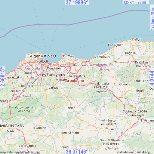
Arbatache GPS coordinates[2]
36° 38' 15.828" North, 3° 22' 16.572" East
| Map corner | latitude | longitude |
|---|---|---|
| Upper-left | 37.19986°, | 2.66815° |
| Center: | 36.63773°, | 3.37127° |
| Lower-right: | 36.07146°, | 4.0744° |
| Map W x H: | 125.5×125.5 km | = 78×78mi |
| max Lat: | 36.92917° ⇑20.5% North |
| Arbatache: | 36.63773° |
| min Lat: | ⇓79.5% South 22.785° |
| min Long | Arbatache | max Long |
| -8.14743° | 3.37127° | 8.46667° |
| W 48.4%⇐ | ⇒51.6% E |
Elevation
Elevation of Arbatache is 150 m = 492 ft, and this is 288.5 m = 947 ft below average elevation for this country.
| Max E: |
1392 m = 4567 ft | 64.7% |
| Avg. | 438.5 m = 1439 ft | |
| Arbatache | 150 m = 492 ft | |
Min E: |
5 m = 16 ft | 35.3% |
See also: Algeria elevation on elevation.city.
Geographical zone
Arbatache is located in North temperate zone (between Tropic of Cancer and the Arctic Circle). Distance of this Northern Tropic circle is 1467.8 km =912 mi to South.| Distance of | km | miles | from Arbatache |
|---|---|---|---|
| North Pole | 5933.3 | 3686.8 | to North |
| Arctic Circle | 3327.4 | 2067.5 | to North |
| Tropic Cancer | 1467.8 | 912 | to South |
| Equator | 4073.7 | 2531.3 | to South |


Nearby cities:
15 places around Arbatache: (largest is in red/bold)
• Aïn Taya
18.9 km =11.7 mi,  336°
336°
• Bab Ezzouar
19.5 km =12.1 mi,  300°
300°
• Beni Amrane
19.9 km =12.4 mi,  80°
80°
• Bordj el Kiffan
20.2 km =12.6 mi,  307°
307°
• Boudouaou
10.5 km =6.5 mi,  19°
19°
• Boumerdas
17.1 km =10.6 mi,  33°
33°
• Dar el Beïda
16.5 km =10.3 mi, 300°
• Khemis el Khechna
3.9 km =2.4 mi,  290°
290°
• Lakhdaria
21.4 km =13.3 mi,  112°
112°
• Larbaâ
21 km =13 mi,  247°
247°
• Meftah
13.4 km =8.3 mi,  261°
261°
• Ouled Moussa
5.2 km =3.2 mi,  355°
355°
• Reghaïa
11.3 km =7 mi,  345°
345°
• Rouiba
13.8 km =8.6 mi,  324°
324°
• Thenia
19.2 km =11.9 mi,  59°
59°
Sources, notices
• [Note1] Compared only with cities in Algeria existing in our database
• [Src1] Map data: © OpenStreetMap contributors (CC-BY-SA)
• [Src2] Other city data from geonames.org with taken over terms of usage.
• [Src3] Geographical zone / Annual Mean Temperature by Robert A. Rohde @ Wikipedia
